
Project description
This page provides an overview of the project design, project phases, key activities and program. It summarises the design history of the T2D Project including the key design changes that occurred between 2021 and 2022.
- Summary
Download a summary of the PAR in PDF format
Overview of the North-South Corridor
The North-South Corridor (NSC) is a major route for north and south-bound traffic in the Greater Adelaide region, consisting of 8 key road links, 7 of which have already been constructed and are operational. The T2D Project is the final link of the NSC to be completed.
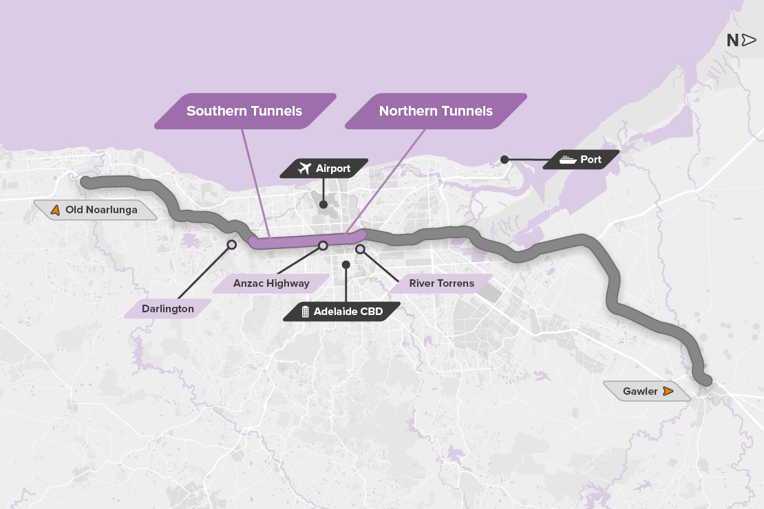
Image: River Torrens to Darlington in relation to the North-South Corridor.
Since the late 1990s, the South Australian and Australian governments have invested nearly $5 billion in creating the non-stop sections of the NSC. Through these significant investments, 67.5km of the NSC’s 78km have now been upgraded to a free flowing, non-stop motorway standard.
The NSC is one of Adelaide's most important transport corridors providing essential transport links to local residents and businesses, as well as to key employment centres and international gateways, including Adelaide Airport and Port Adelaide.
The completion of the NSC will improve the state’s competitiveness in a national and global market by delivering improved freight connections between Port Adelaide and South Australia’s primary industries and businesses, while supporting commuters to enjoy a more reliable, safer journey across Adelaide.
Overview of the T2D Project
Using a combination of tunnels, lowered and surface-level motorways, and underpasses at key intersections, the T2D Project will finalise 78km of non-stop motorway between Gawler in the north and Old Noarlunga in the south.
The project alignment extends 10.5km from West Hindmarsh to Darlington, connecting to the Torrens Road to River Torrens Project to the north and the Darlington Upgrade Project to the south.
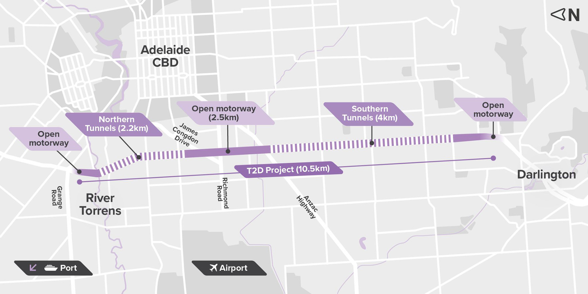
Image: River Torrens to Darlington (T2D) project extent.
The Project Design has been developed to allow for uninterrupted journeys along the NSC. The project will allow motorists to bypass 21 sets of traffic lights, reducing travel time by up to 30 to 40 minutes between the River Torrens / Karrawirra Parri and Darlington in weekday peak times.
For more information on the T2D Project objectives and benefits visit Project benefits. And for more information about the design visit About the design.
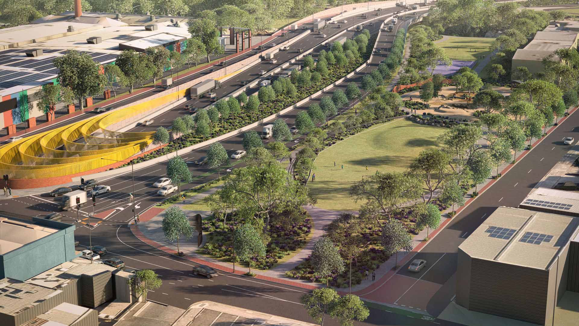 Artist's impression: Increased open space on the eastern side of motorway.
Project area
About 60% of the motorway will be twin three-lane tunnels with the remainder open motorway. The current alignment can be viewed in the project map.
To enhance benefits from the T2D Project, there will be $850 million worth of additional network and amenity upgrades along and around the project corridor to enable motorists to get to and from the corridor. For more information visit Broader network upgrades.
Design development
Improvements to the NSC were first identified in the 1968 Metropolitan Adelaide Transport Study. Since then, it has been a part of numerous government plans and strategies.
Various options have been explored for the T2D alignment and configuration across the past ten years, including open or elevated motorways, a dual corridor using South Road and Marion Road, a single continuous tunnel, hybrid tunnel and open motorway solutions.
These were assessed for connectivity, safety, whole-of-life costs during construction and operation, flexibility of construction and community feedback.
2010-2018 - Strategic responses
- North study and South study.
- Online motorway options or offline motorway options.
- Open motorway.
2018-2021 - River Torrens to Darlington options development
Strategic merit test
- Open motorway.
- 7 tunnel options.
Options assessment process
- Open motorway.
- Hybrid (open motorway and tunnels).
- Long tunnels.
Detailed multi-criteria assessment
- Open motorway.
- Hybrid (open motorways and tunnels).
Reference Design
- Hybrid+ (December 2021 Reference Design).
2022-2024 - T2D Project Design
Project review of cost / scope / outcomes
- T2D Project Design (December 2022)
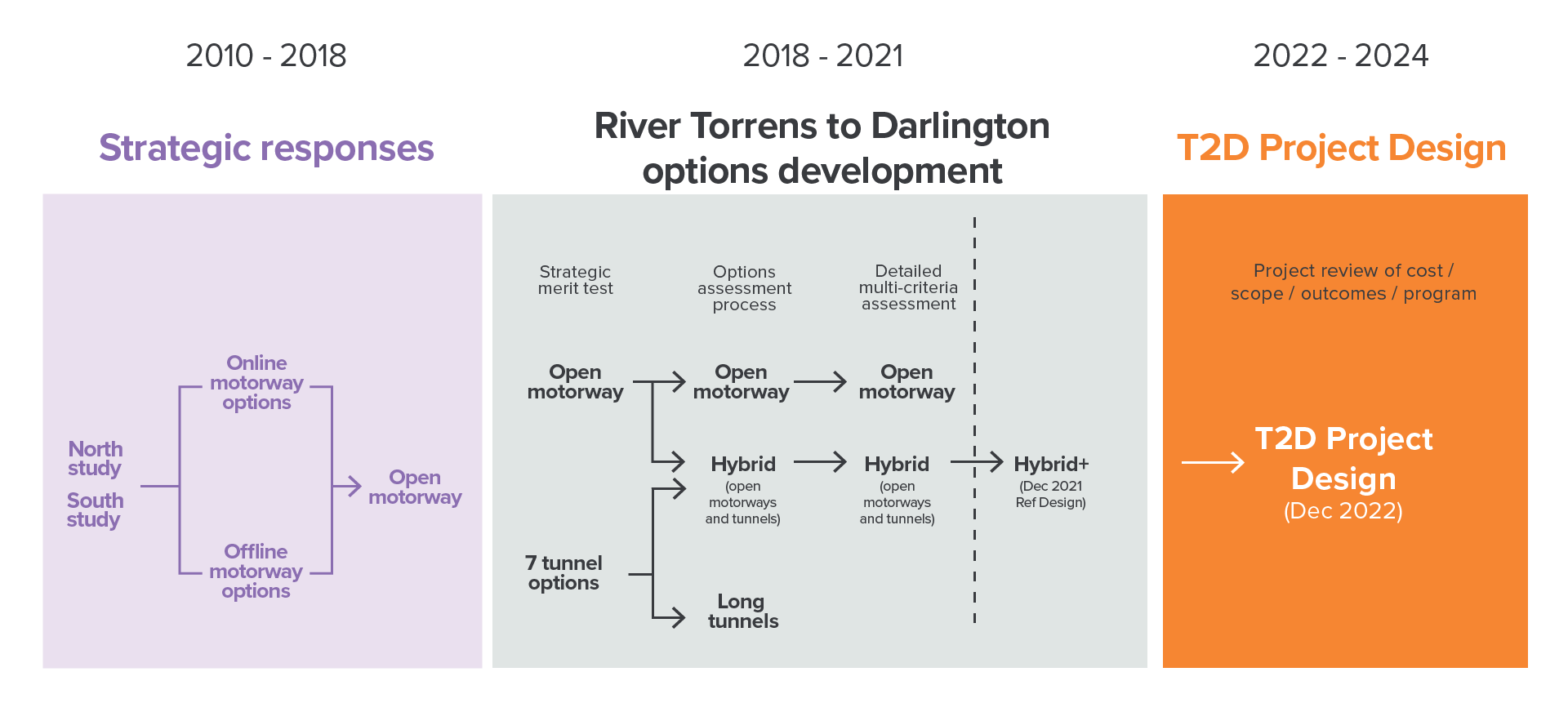
Image: Design development timeline diagram.
The T2D Project has significantly evolved since 2010, when the first planning studies were undertaken. This extensive process has considered many factors and different options to develop the preferred alignment and road configuration, resulting in the Project Design (the subject of this PAR).
Ultimately, a hybrid solution consisting of both open motorway and medium length tunnels was selected based on minimising community disruptions including property acquisitions, while creating greater economic benefits through urban-redevelopment opportunities and ensuring more businesses can stay open during construction.
This early hybrid design (2021) was further developed to deliver broader benefits to the community. This included review of the design in consultation with the community and stakeholders to ensure the project will deliver the best possible outcome for road users and those who live and work along the corridor.
To enhance the design and incorporate further community feedback, the early hybrid option underwent further investigations and refinement in 2022. This resulted in a shortening of the Southern Tunnels, redesign of the Northern Tunnels, northern portal and amendments to interchanges at Anzac Highway, Richmond Road and James Congdon Drive. These changes have resulted in the current Project Design.
Acknowledging the size and scale of the motorway, the Project Design has sought to protect as much of the existing surface land as practicable. Traversing a highly urbanised environment within Adelaide’s western and southwestern suburbs, the T2D Project design has decreased impacts on large portions of these suburbs by using tunnels for the majority of the project (approximately 60%).
Compared with other design options considered, the current project design option will:
- minimise impacts on the local community by reducing land acquisition that would otherwise be required for open motorway solutions
- reduce business closures by approximately 40%
- reduce impacts on around 50 sites of cultural and heritage importance.
The evolution of the design, from planning studies to the Project Design, is summarised in the below table.
| Time | Overview |
|---|---|
Planning Studies | |
2010 – 2014 | Early planning studies considered numerous infrastructure and non-infrastructure ideas to solve the congestion issues on South Road. |
2012 | The ‘North Study’ identified and assessed options between Regency Road and Anzac Highway. |
2014 | The ‘South Study’ identified and assessed options between Anzac Highway and Darlington. |
2017 | A planning summary report identified two open motorway options: one that was 'on-line' following the existing South Road corridor, and the other 'off-line' that would be located in the south, following the rail corridor. |
2018 | Advancements in tunnelling technology, combined with a revised set of project objectives, focusing on wider benefits and minimising community impacts, saw tunnel-based options reconsidered. |
2019 | New options were explored, with a wide range of tunnel options assessed. This included different combinations of tunnel lengths, lanes, connectivity and locations, including a single long tunnel, as well as the previously preferred open motorway option. Two preferred design options for the T2D Project emerged based on their ability to meet project objectives. These were:
|
2020 | The preferred options were developed further and assessed against their ability to meet the project objectives, including consideration of costs, economic outcomes, community impacts and benefits. The hybrid option was recommended due to its lower community impacts, improved economic benefits and future land use opportunities compared with the open motorway option. The hybrid option was further refined to become the hybrid + concept design. This further maximised economic benefits and reduced community impacts, minimising property acquisition requirements and effects to culturally important sites. |
2021 | The hybrid + concept design was developed into the 2021 Reference Design. The final business case for the project was completed and submitted to Infrastructure SA, Infrastructure Australia and the Australian Government as part of funding and approval requirements for the project. The 2021 Reference Design was released for community consultation. |
2022 | In response to community feedback on design elements of the 2021 Reference Design, and ongoing technical inputs, a review of the project design was undertaken. As a result, some elements and constraints of the 2021 Reference Design were changed or refined. The following changes are included:
In December 2022, the Project Design was released for community consultation. As detailed in this PAR, environment, heritage and social impact assessments were undertaken to understand and minimise the potential impacts from construction and operation based on the Project Design. |
2023 - 2024 | Further design refinement and details continue ahead of the appointment of a head contractor, planned for Q3 2024. |
Learn more about the benefits comparing the 2021 design to the December 2022 Project Design.
Project staging and timeframe
The project has numerous key phases:
Planning and design phase
Establishes the road alignment, layout and identified associated project area. Extensive investigations, studies and assessments across various areas including traffic, heritage, noise, geology, air quality, soil and groundwater are undertaken.
Early works and site establishment phase
Requires utility services relocation or adjustment to suit the new T2D Project Infrastructure. Enabling works will establish temporary sites to support ongoing construction. Facilities for the tunnel boring machines (TBMs) will be constructed near the Southern Tunnels and Northern Tunnels laydown areas. For more information on TBMs visit Tunnel boring machine.
Tunnel and portal works phase
Begins at Darlington, with preparation at the southern portal of the Southern Tunnels to create a launch site for the TBMs, taking nearly two years to complete. After completion of the Southern Tunnels, the TBMs will be moved to the launch site of the Northern Tunnels. Tunnel construction will include:
- excavation using TBMs, soil removal and installation of tunnel lining
- road construction, including drainage, barriers and road surfaces
- mechanical and electrical fit-out installing ventilation facilities (where required), emergency and maintenance requirements, signage, lights, CCTV cameras and monitoring and communication systems.
Open motorway civil and structural work phase
Includes the construction of sections of open motorway to connect the lowered or surface motorway, elevated roads and surface connections to the existing road network as well as the intelligent traffic monitoring infrastructure.
Nearing the construction completion of each section, Southern Tunnels, Northern Tunnels and adjacent open motorway, the motorway systems will be tested and commissioned to ensure the motorway is operable and safe for all users. Once each section passes the relevant testing and commissioning requirements they will be opened to traffic.
The project timeline will be refined over time. The major works contract will be awarded in Q3 2024 and will commence with Detailed Design and approvals. Major construction will begin in 2025, with major tunnel works starting in 2026. Full funding by the Australian and South Australian governments facilitates project completion in 2031. For further information read details on construction activities and how they will progress.
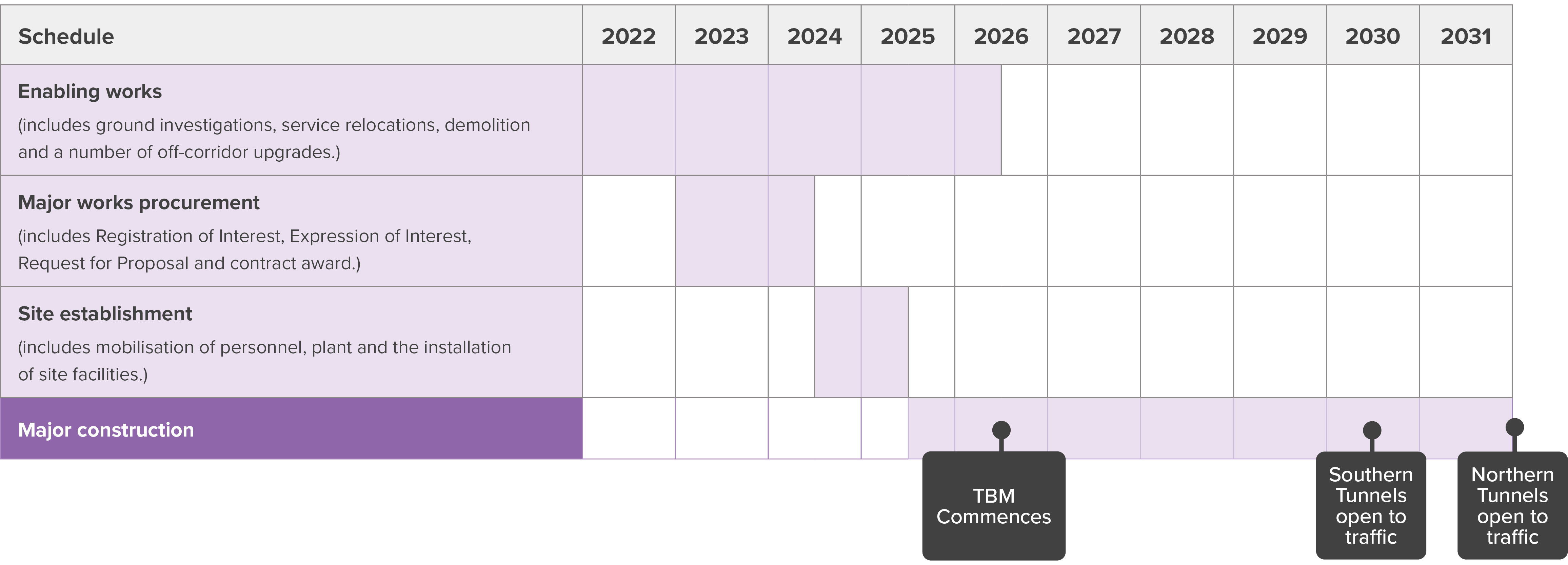 Image: Indicative T2D Project timeline.
Project land and setting
The T2D Project area is characterised by a diverse range of highly urbanised areas with a mix of land uses and surrounding communities. The existing road corridor is highly modified and located within metropolitan Adelaide.
The northern section of the project passes through mainly residential land, whereas the southern section is dominated by commercial and retail uses.
South Road provides access to multiple significant destinations within metropolitan Adelaide, including the Adelaide Central Business District (CBD), Adelaide Airport, large retail shopping centres, sporting ovals and stadiums, hospitals, schools and universities.
The main economic-activity destinations within and surrounding the project corridor include Hindmarsh, Mile End and Thebarton, Edwardstown and Melrose Park, Tonsley and the Flinders health and education precinct.
Key precincts and land use along the T2D Project alignment include:
- the River Torrens / Karrawirra Parri at the north of the project alignment
- retail/commercial hubs at Brickworks Marketplace (Torrensville) and Castle Plaza (Edwardstown)
- public transport connections at the South Road Overpass (tram) and Emerson station (train), high frequency bus connections south of Anzac Highway
- higher-density residential options along Anzac Highway (Urban Corridor (Boulevard) Zoning)
- recreation/open space at Kings Reserve, Thebarton Oval, Richmond Oval (Hisense Arena), and Glandore Oval
- Historic and Character Overlay as defined by the Planning and Design Code in suburbs including Mile End, Richmond, Everard Park, Glandore and Edwardstown
- Local and State Heritage Places, including the Hindmarsh Cemetery and Thebarton Theatre, Maid of Auckland Hotel and St Mary's Anglican Church
- the Tonsley Innovation District at the south of the project alignment.
Photo: Brickworks Marketplace and Taylors Bridge, River Torrens / Karrawirra Parri.
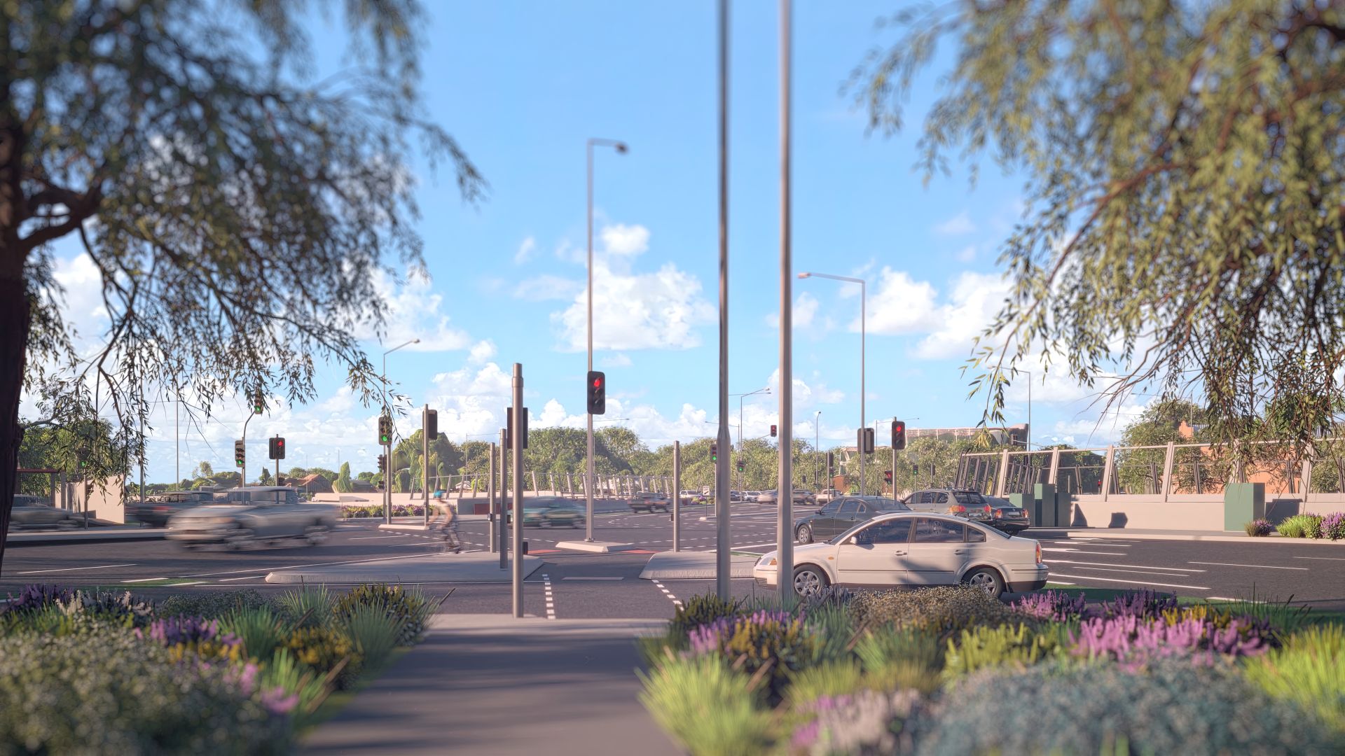
Mature trees within the South Road corridor are present in the north, with limited trees in the open motorway and in the south. Amenity vegetation within the project area primarily comprises of planted trees and shrubs in the north, around the Gallipoli Underpass, within private property subject to acquisition and roads intersecting South Road.
The existing South Road streetscape is generally dominated by incremental, ad hoc development, surface carparking facing the road, overhead electrical services, relatively narrow footpaths and an absence of street trees. Crossing South Road is hazardous for pedestrians with limited pedestrian activated crossings with priority given to traffic capacity and flow.
Significantly, the project passes over the River Torrens / Karrawirra Parri and two creeks – Keswick Creek and Brownhill Creek / Willawilla.
More than a motorway
Urban design
A focus on good urban design is a priority to maximise the benefits of the T2D Project and realise its broader potential.
An Urban Design Strategy (UDS) has been developed to guide the T2D Project. The UDS will ensure good urban design outcomes for the T2D Project, not only for the motorway but also in neighbouring communities.
The purpose of the UDS is to:
- analyse relevant background strategies, policies and plans
- analyse the local context of the project corridor, including its visual and landscape aspects
- analyse stakeholder values and priorities heard through engagement
- establish the urban design vision and outcomes to be achieved
- provide contextual guidance for key locations along the corridor
- provide technical guidance for a range of infrastructure and public realm elements.
The UDS will be used:
- to provide consistent urban design guidance and direction throughout all stages of the T2D Project
- to support various stages of stakeholder engagement, to align its direction with the priorities of communities businesses, local government and Traditional Custodians
- to form the basis of urban design contract requirements, together with the T2D Project Specification, which will be jointly used to evaluate design responses received during the procurement process from bidding delivery teams.
The UDS will be used by contractors engaged to design and deliver all urban and landscape design components of the T2D Project and will help to achieve consistency in corridor design and broader, holistic outcomes.
Artist's impression: Urban design and landscape along the T2D Project.
The UDS applies to all urban design, landscape and creative elements of the T2D Project. As required, the UDS will also be used to guide urban design works included in the Broader Network Upgrades program and city shaping initiatives to achieve consistent urban and landscape design outcomes across the corridor.
Learn more about the T2D Project’s Urban Design Strategy.
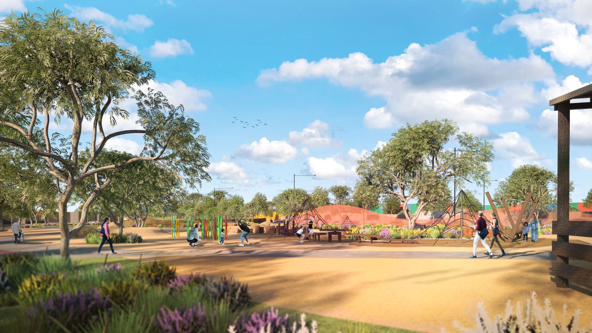
City shaping
City shaping initiatives embody an approach that identifies broader benefits and opportunities to improve connections, develop places, increase greening and support communities along the project corridor. These opportunities build on Adelaide’s renowned and celebrated liveable-city status.
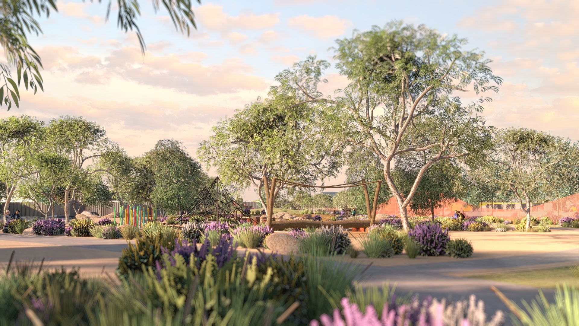
Artist's impression: South Road playground and shared-use path.
City shaping also identifies ways to mitigate adverse amenity outcomes for different components of the project. This has been applied during design development, enabling outcomes to be included early in the design process and ensuring the preferred outcomes match the size and scale of the project.
Consistent with the Urban Design Strategy (UDS), $125 million is committed to specific city shaping initiatives to be delivered over the period of the project to respond to community and stakeholder feedback.
The city shaping is expected to have a positive effect on local communities and businesses through:
- improved access to public open space and sporting facilities through new investments in parks, reserves and infrastructure
- safer streets for cycling, encouraging more active travel and healthier communities
- additional tree planting, landscaping, and water-sensitive urban design to improve tree canopy and reduce the urban heat-island effect
- development of retail, commercial and light industrial premises, potentially supporting acquired businesses and stimulating new private investment
- mitigating the effects of land acquisition and community severance arising from the construction of the surface-level sections of the T2D Project
- enhanced east-west connectivity for areas above the tunnels, including removing a set of traffic lights on South Road at Edwardstown.
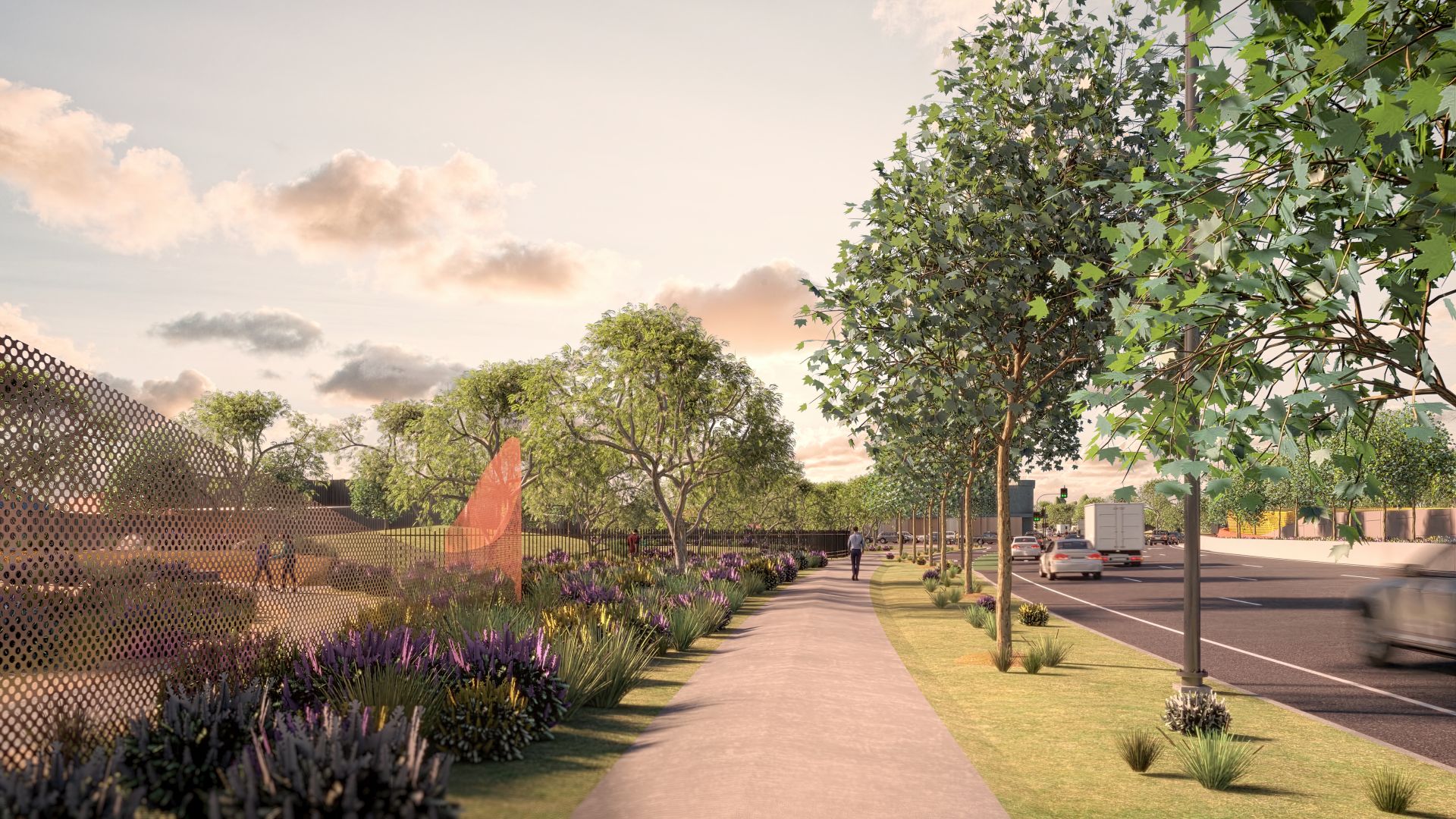
Artist's impression: South Road shared-use path.
Land acquisition
The Government of South Australia has provision under the Highways Act 1926, together with the Land Acquisition Act 1969 (the Act) to acquire properties for road construction. The Act sets out South Australia's land acquisition process and the compensation entitled to affected parties for surface level acquisition. Land can be acquired under the Act by agreement or by a compulsory process, the various methods are as follows:
- Government initiated – this occurs when contact is made with the affected parties by the Department's Property Acquisition Team and a Notice of Intention to acquire land is issued setting out the rights, processes and timeframes of acquisition under the Act. An independent valuer assesses the land’s actual value to inform the level of compensation prior to any offer provided
- landowner initiated – this occurs when property is listed for sale on the open market and the government purchases the land through a non-statutory process.
The December 2022 Project Design requires a total of 524 properties at surface level for the T2D Project, including full and partial acquisition. Land is required at surface level to deliver the open and lowered motorway, tunnel portals, relocation of essential infrastructure services (beyond the road footprint) and construction purposes.
For the T2D Project, underground land is required for the construction of the Southern and Northern Tunnels. Underground land acquisition requirements are determined by the location of the tunnels. Land from the surface to 10m deep does not need to be acquired for the project.
The underground land required includes the land occupied by the tunnel, as well as an additional Tunnel Exclusion Area around each tunnel to protect its integrity.
In the case of underground land acquisition, the government initiates the compulsory acquisition of the required land through a statutory process enabled by Part 4A of the Act. Upon the publication of a Notice of Acquisition in the South Australian Government Gazette ownership is transferred to the Commissioner of Highways and affected parties are notified as soon as reasonably possible. We will directly contact affected parties in late 2024 to share more information and start to work through the process.
For more information visit Property acquisition.
Video: An Introduction to Property Acquisition.
Native title
In South Australia, native title is predominantly administered through the Commonwealth Native Title Act 1993 (Cth) (NTA). The Commonwealth NTA recognises the rights and interests of Aboriginal and Torres Strait Islander people in land and waters according to their traditional laws and customs, governs the process to establish native title rights and interacts with land for which native title exists, and provides for the establishment of Indigenous Land Use Agreements (ILUAs).
The Native Title Act 1994 (SA) is a state-based Act enacted to parallel the Commonwealth NTA prior to amendments made in 1998 (Native Title Amendment Act 1998). The South Australian NTA provides the Environment, Resources and Development Court, and the Supreme Court of South Australia, with jurisdiction to deal with native title matters.
In March 2018, the Federal Court provided a ruling, which determined that native title exists (native title land) for 17 parcels of land within the Kaurna Peoples Native Title Claim Area.
None of the parcels of land are within or in proximity to the T2D Project. As a result, the T2D Project does not encroach on any of the designated native title land and none of the land will be impacted/modified by the project.
The T2D Project is subject to an Indigenous Land Use Agreement (ILUA) between the Kaurna People and the Attorney General for the State of South Australia (Tribunal Number SI2018.004). The Native Title Vision database, maintained by the National Native Tribunal, shows that native title does not exist over the T2D Project land.