Surface water
Surface water is water that flows over or is stored above ground and can be present in a permanent fashion (throughout the year) or semi-permanent/seasonally (part of the year). Surface water is integral to the health and sustainability of Adelaide’s urban freshwater rivers, creeks and ultimately the marine environment of the Gulf St Vincent.
There are multiple locations where the T2D Project intersects watercourses within water catchments, and obstruction of existing flow paths in these areas has the potential to alter the existing flood risk.
Changes to the surface water environment during construction of the T2D Project could increase flood risk to the community, the surrounding properties and infrastructure as well as degrade the watercourses that rely on surface water if not appropriately managed. Therefore, the project has been designed to minimise risk to the health of surface water ecosystems and to maintain current water flows and patterns across the Adelaide Plains.
- Summary
Download a summary of the Surface water impact assessment in PDF format
Approach
The assessment of potential surface water impacts of the project included multiple investigations that have been undertaken over a number of years as the project design evolved. For more information visit About the design.
The potential for the project to impact surface water has been assessed by undertaking the following investigations, workshops and modelling:
- stormwater, hydrology and flooding investigations that document the potential for flooding impacts from a range of design storm events. These investigations are then used to develop flood mitigation strategies and stormwater drainage infrastructure design for the project
- a water quality risk assessment (WQRA) workshop that identified early on, the potential operational and construction risks associated with water quality by the proposed infrastructure
- undertaking water quality modelling to inform water quality stormwater design. This included analysing the potential impacts of the proposed design on stormwater quality, consideration of Water Sensitive Road Design (WSRD) and Water Sensitive Urban Design (WSUD) techniques and potential for vegetated stormwater treatment infrastructure (STI).
These assessments identified that there are activities and impacts relating to surface water which are interrelated to site contamination, geology and groundwater and ecology. This is particularly the case regarding potential impacts to the three surface water bodies (River Torrens / Karrawirra Parri, Keswick Creek and Brownhill Creek / Willawilla). To avoid repetition these activities and impacts are described within the site contamination, groundwater and ecology assessments and are not replicated in this surface water assessment.
Assessment area
The surface water assessment area as shown in the map below extends to floodplain catchments, the underground stormwater drainage networks, current receiving environments and stormwater discharge systems along and adjacent to the South Road corridor.
Map: Surface water assessment area.
Map disclaimer
Surface water features
There are many surface water features that have been considered as part of the numerous assessment and investigations undertaken to support the design of the T2D Project.
Hydrological system
The distribution of surface water in the associated catchment is technically known as a hydrological system. It considers rain, evaporation, surface storage and water runoff within water catchments over time.
The majority of this project is located within the Patawalonga Basin and Torrens River catchments, with the northern most portion encroaching into the Port Adelaide catchment as shown in the assessment area map.
As these water catchments are highly modified, drainage is provided by a system of underground pits, pipes and culverts which transfer water runoff from the surrounding areas to one of the major watercourses that then flow out to Gulf St Vincent.
The project corridor crosses the River Torrens / Karrawirra Parri, the Keswick Creek and Brown Hill Creek / Willawilla, that each flow in an east-west direction across South Road. Viaduct Creek, which crosses South Road just south of the project corridor, is in proximity and also needs to be considered by the project. Refer to the assessment area map for the watercourse locations.
Urban stormwater catchments
The urban stormwater catchments along the project corridor have also been assessed. These catchments generally collect stormwater by gutters, pits, pipes and culverts (stormwater drainage infrastructure) and direct water into locations at rivers and creeks that, in turn, discharge into Gulf St Vincent.
Studies conducted by the City of Charles Sturt, City of West Torrens, City of Unley and the City of Mitcham have previously confirmed that there is a potential for flooding if the capacity of the stormwater infrastructure in local catchments is overwhelmed.
The patterns of flooding and locations potentially most impacted are similar to those shown on the watercourse flooding projections, near the intersection of Ashwin Parade, around James Congdon Drive, the area just south of Anzac Highway and at the Glenelg Tramline.
Tunnel sections of the project alignment do not result in significant changes to the urban water catchment as the surface catchment conditions do not change. The project design has focussed on opportunities to mitigate changes to the urban stormwater catchments for the lowered road and tunnel portals, where the existing stormwater infrastructure has the greatest potential to be impacted by the project.
Surface water quality
To better understand existing surface water quality and to anticipate any changes that may result from construction and operation of the project, baseline water quality monitoring at 11 locations commenced in 2022. Locations were sited across the three watercourses that cross the project corridor, but also the Sturt River / Warriparri, the Patawalonga and Barcoo Outlet where surface water drains into the Gulf St Vincent.
The following map shows surface water monitoring locations and surface water bodies around the project corridor:
Map: Baseline surface water quality and flow monitoring locations.
Map disclaimer
At each of the monitoring locations field samples were tested for general water quality condition and samples were taken for off-site laboratory chemical analysis. The surface water assessment criteria was sourced from relevant industry guidelines, including the Australian and New Zealand Guidelines for Fresh and Marine Water Quality and per- and polyfluoroalkyl substances (PFAS) National Environmental Management Plan (Version 2.0 – January 2020).
Analysis | Assessments |
|---|---|
On-site water quality analysis |
|
Off-site laboratory analysis |
|
Some health and freshwater ecosystem criteria were found to be occasionally exceeded including copper, lead, nitrogen, turbidity, and reactive phosphorus. This was as anticipated and common for similar areas given the location of the project corridor, the local geology and surrounding land uses.
These project water quality monitoring results, considered in context with wider water quality monitoring results undertaken by others within the catchment will contribute to the project’s WQRA. The WQRA identified the current baseline conditions, assesses the risk associated with discharge of impacted groundwater and identifies suitable discharge criteria.
The existing surface water quality within and adjacent to the project corridor does not always meet water quality guideline values set by the Environment Protection Authority (EPA). This is mainly due to the existing adjacent catchment area land uses. The final design of the project will therefore need to minimise the remobilisation of potentially contaminated sediment that could adversely impact water quality during construction and operation.
Flooding
Flooding is typically a temporary overflow of a watercourse or body of water which affects normally dry areas.
The potential for the project to affect watercourse capacity and result in flooding, including consideration of future climate change scenarios has been assessed. These assessments have confirmed the project needs to avoid or minimise adverse effects on current surface water environments during construction and operation to minimise the risk of contributing to future flooding events.
Previous flooding investigations have been undertaken for each of the watercourses in the project area in addition to the catchments of the underground drainage systems that flow to them.
Flooding for the River Torrens / Karrawirra Parri was investigated and mapped in the late 1990’s and flooding of Keswick Creek and Brown Hill Creek / Willawilla assessed as part of the Brown Hill Keswick Creek Stormwater Management Plan completed in 2017.
Existing conditions for each of the watercourses that cross the project corridor, in addition to Viaduct Creek (south of the project corridor) and the urban drainage catchment, are described in detail below.
River Torrens / Karrawirra Parri
The River Torrens / Karrawirra Parri crosses the project corridor in the Northern Tunnels section. The river crosses the corridor to the north of West Thebarton Road and south of Adam Street in Hindmarsh. In this location the river is contained in a modified earth channel, with banks retained in part by timber and concrete walls.
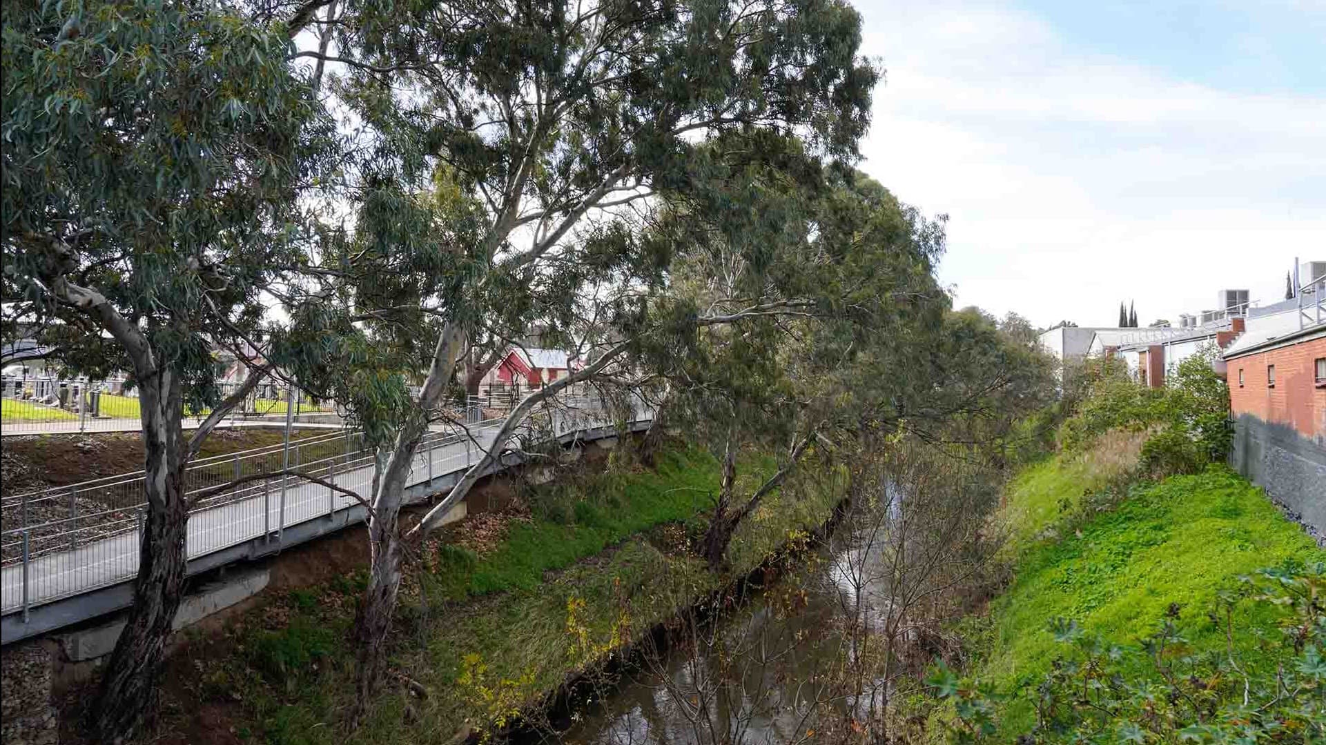
Photo: River Torrens / Karrawirra Parri corridor, east of the South Road bridge.
The annual exceedance probability (AEP) measures the probability of a flood being equalled or exceeded in any given year. Previous investigations have confirmed that the River Torrens / Karrawirra Parri between Port Road and South Road has sufficient capacity to carry an annual maximum flood event that has a 0.5% likelihood of occurring in any given year (AEP). This can also be described as a 200-year average recurrence interval AEP event.
Modelling in this location indicates floodwater is contained in the main river valley upstream of Port Road, while floodwater is likely to spill to the north and south downstream of Port Road. Along South Road, the depth of flooding is greatest near Susan Street (north of the River Torrens / Karrawirra Parri, east of South Road) due to a natural low spot in the terrain.
As a result, the potential for increased flood-depth along the east of the corridor has been identified and protection will be required at surface level of the proposed tunnel portals, south of the River Torrens / Karrawirra Parri, between the River Torrens / Karrawirra Parri and Ashwin Parade. Consideration of cross-corridor flows north of the river also needs incorporation in the design.
Keswick Creek and Brown Hill Creek / Willawilla
While these are two separate watercourses, both within the open motorway section of the project, they have been considered together, as their flooding behaviour is inter-related with overflows from Brown Hill Creek / Willawilla moving northward towards Keswick Creek.
Keswick Creek crosses the project corridor north of James Congdon Drive and is contained in a concrete lined open channel.
Brown Hill Creek / Willawilla crosses the project area north of the existing Gallipoli underpass and is contained in a modified earth channel, with banks retained in part by gabion and concrete block walls.
Flooding from the Brown Hill – Keswick Creek system for events up to a 1% AEP (100-year average recurrence interval) flood event has been mapped for existing conditions as part of the Keswick and Brown Hill Creek / Willawilla stormwater management plan.
The flood mapping shows that in such an event, flows have the potential to escape from Keswick Creek to the east of the project corridor, crossing the alignment at various points between Alexander Avenue and James Congdon Drive. The main overflows were identified to occur north of Richmond Road.
Brown Hill Creek / Willawilla is mapped to overflow east of Anzac Highway with flood levels extending to the intersection between the proposed project corridor and Anzac Highway and between Alexander Avenue and Richmond Road. The existing Brown Hill Creek / Willawilla culvert crossing has sufficient capacity to take the 1% AEP (100-year average recurrence interval) flows and does not require upsizing.
The potential for flooding within the Brown Hill Creek / Willawilla and Keswick Creek system has been shown to impact the project area in the section between James Congdon Drive and Cross Road. The Keswick and Brown Hill Creek / Willawilla stormwater project is a collaborative undertaking by five city councils, with work scheduled to be undertaken progressively between 2022-2036 to address flooding from these creeks for events up to a 1% AEP (100-year average recurrence interval) flood event. Works include upstream diversions to reduce flows away from both creeks and ensuring the culvert crossings across South Road have sufficient capacity to provide for the revised water flows.
The timing of these works is subject to funding and is currently proposed for completion in the early 2030s. In the interim, depending on timing of construction of the stormwater management plan projects, the project design needs to ensure protection of the lowered motorway within the open motorway section from these potential flooding flows.
Additional modelling undertaken by the T2D Project for the Brown Hill Creek / Willawilla and Keswick Creek catchments exceeding 1% AEP (100-year average recurrence interval) flood event has been undertaken. Under existing conditions, this indicates the potential for inundation of the existing South Road corridor between Sir Donald Bradman Drive and Anzac Highway, with the majority concentrated at the James Congdon Drive intersection. The design needs to ensure protection of the lowered motorway and the tunnels at the ends of the open motorway section from these potential flows, as well as the provision of cross corridor flows for both creeks.
Viaduct Creek
Viaduct Creek is to the south of the project corridor. The creek enters underground concrete pipes to the south-east of the intersection of Ayliffes Road and South Road and crosses under South Road towards the Tonsley Innovation District.
A flooding assessment for the Viaduct Creek catchment has previously been investigated as part of the Sturt River Urban Catchments Stormwater Management Plan in 2017. The mapping shows flows from the creek are contained within the underground pipe system in a 1% AEP event. The pattern of flooding in the area north of Ayliffes Road and east of South Road shows flows in a 1% AEP (100-year average recurrence interval) flood event extends in a northerly direction parallel to the North-South Corridor and does not cross the current South Road alignment where the project corridor is proposed.
Current modelling shows that under existing conditions and during extreme flood events, floodwater can escape from the creek at the upstream end of the culvert at Ayliffes Road. These floodwaters are directed westward along Ayliffes Road and then cross the Ayliffes Road/South Road intersection. From there, most of the floodwaters travel northward along the eastern (southbound) carriageway of South Road with some potential floodwater extending across South Road corridor at the Tonsley Bridge.
While this creek is not directly impacted by this project, mitigation from the implications of overflows from the creek to the southernmost extent of the project area needs consideration during design.
Impacts and mitigation measures
Construction and operation of the project has the potential to cause impacts to surface water, both in quantity and to quality if the design does not properly incorporate appropriate features or mitigation measures. An evaluation of each potential surface water impact has been undertaken for both the construction and operational phases of the project.
The potential impacts to surface water have been assessed by applying the project’s assessment methodology to the surface water assessment area.
The objective of the assessment methdology is to document and assess the environmental (including heritage) and social risks from the project and identify management and mitigation measures to reduce these risks. The potential impacts to surface water, divided into each of the three project sections are summarised below.
Northern Tunnels
- flood impacts to the project and surrounding area due to disruption or obstruction to existing floodplain flow paths across the project corridor or damage or inundation of existing stormwater drainage network assets
- contamination and water quality impacts to receiving waters (River Torrens / Karrawirra Parri) including increased turbidity, sedimentation from construction activities, litter, spills, discharge of untreated dewatering or construction water and operational tunnel and open motorway drainage water
- potential impacts to River Torrens / Karrawirra Parri capacity (leading to flooding) and water quality (bed and banks erosion) from the proposed bridge crossing.
Open motorway
- flood impacts to the project and surrounding area due to disruption or obstruction to existing floodplain flow paths across the project corridor or damage or inundation of existing stormwater drainage network assets
- contamination and water quality impacts to receiving waters (Keswick Creek and Brown Hill Creek / Willawilla) including increased turbidity, sedimentation from construction activities, litter, spills, discharge of untreated dewatering or construction water and operational tunnel and open motorway drainage water
- impacts to Keswick Creek and Brown Hill Creek / Willawilla waterway capacity (leading to flooding) and water quality from their proposed culvert crossings.
Southern Tunnels
- flood impacts to project and surrounding area due to disruption or obstruction to existing floodplain flow paths across the project corridor or damage or inundation of existing stormwater drainage network assets
- contamination and water quality impacts to receiving waters of the Sturt River / Warriparri (downstream receiving water) including increased turbidity, sedimentation from construction activities, litter, spills, discharge of untreated dewatering or construction water and operational tunnel and open motorway drainage water.
Construction impacts
The activities that result in the potential for construction impacts have been identified and mitigation measures to minimise those impacts defined. These are summarised in the following table:
Potential construction impacts | Mitigation measures |
|---|---|
Construction activities, including dewatering discharge changing the direction and flow of surface water, causing ponding or flooding in low lying areas and/or increase in flood frequency, velocity or level affecting the community or structures within urban catchments. | The project will:
|
Increased turbidity (cloudiness) levels in receiving water bodies and potential for excessive sediment accumulation within the bed of watercourses from surface water runoff from construction and excavation activities. Increase in litter from construction activities. Spills including hazardous material affecting waterways released into the receiving waterways resulting in adverse impacts to receiving water environments. Construction activities resulting in river and creek bed or bank erosion impacting on water quality in the receiving water environments. | The project will:
|
Construction activities including dewatering causing unintended damage to the existing drainage network assets resulting in an increase in flooding risk. | The project will:
|
Treatment and disposal for combined dewatering and surface water flows captured to surface water bodies. | The project will:
|
Construction activities impacting existing flow paths (including piped flow) causing variations in flow volumes (both decline and increase from dewatering discharge) to downstream ecosystems. | The project will:
|
Operational impacts
The activities that result in the potential for operational impacts have been identified and mitigation measures to minimise those impacts defined. These are summarised in the following table:
Potential operational impacts | Mitigation measures |
|---|---|
Project infrastructure causing an increase in flood frequency, velocity or level that could affect residents or built assets within the floodplain. A flood event occurring during the operation of the tunnel that inundates the tunnel impacting driver and public safety. | The project will:
|
Water from tunnel drainage network being discharged to watercourses resulting in adverse impacts on receiving water environment. | The project will:
|
How impacts will be minimised or avoided
During design the project has confirmed that application of the Department’s Master Specification (MS), with its links to relevant parts of the Environment and Heritage Technical Manual (EHTM) will be sufficient to mitigate the construction and operational impacts to surface water.
Of relevance to surface water are:
- MS PC-ENV1 – Environmental Management
- MS PC-ENV2 – Environmental Protection Requirements
- MS PC-ENV3 – Environmental Design
- MS PC-SI1 – Site Survey
- MS PC-SI2 – Site Investigations
- MS PC-ST1 – Sustainability in Design
- MS PC-ST2 – Sustainability in Construction
- MS RD-DK-D1 – Road Drainage Design
- MS RD-DK-C1 – Installation of Stormwater Drainage
- EHTM Attachment 6A – Protecting Waterways Guideline
- EHTM Attachment 6B – Water Affecting Activities Best Practice Operating Procedure
- EHTM Attachment 10A – Guideline for the Preparation of a Contractor’s Environmental Management Plan
- EHTM Attachment 10B – Guideline for Environmental Audits in Construction
- The Department’s Sustainability Manual
These MS and EHTM require the project to undertake further assessments and prepare reports during construction.
These include:
- WQRA
- Green Infrastructure Assessment
- supporting investigations and documentations for permits and licenses required by the Green Adelaide Landscape Board and the South Australian EPA
- opportunities for water management documented in the Urban and Landscape Design Report
- CEMP
- establishing, implementing and maintaining a Construction Water Quality Monitoring and SEDMP during construction.
Approvals
The following table provides a summary list of the likely surface water related legislation required to progress the project to delivery.
Legislation | Approval |
|---|---|
Required | |
Wastewater treatment licence in accordance with Schedule 1, Section 3(4)(b) of the EP Act refers to license for the operation of a wastewater treatment plant. This would apply to the operation of water treatment facilities and discharge of treated water. Section 4(6) describes earthworks drainage and is a separate license type under the act. Section 4(4) describes dredging licences for excavation works in watercourse and is a separate license type under the act. | |
| Landscape South Australia Act 2019 (LSA Act) | Under Sections 104 (3) and (4) of the LSA Act, a permit is required for water affecting activities unless the works are approved under another Act, such as the Planning Development and Infrastructure Act 2016, the EP Act or the Native Vegetation Act 1991. As a result, Water Affecting Activity Permits (WAAPs) will be required for each of the three watercourses (River Torrens / Karrawirra Parri, Keswick Creek and Brown Hill Creek / Willawilla) that pass through the project corridor. |
Potentially required | |
| Water Industry Act 2012 | Subject to the project’s final stormwater solution and EPA discussion and approvals provision to pursue an SA Water Trade Waste discharge approval to the sewerage system may be required. |
| EHTM Attachment 6A – Protecting Waterways Guideline | Demonstrate compliance. No specific approval required, however compliance with the EHTM Attachment 6A – Protecting Waterways Guideline needs to be demonstrated. Including conducting a WQRA. |
| EHTM Attachment 6B – Water Affecting Activities Best Practice Operating Procedure | Demonstrate compliance. No specific approval required, however compliance with the EHTM Attachment 6B – Water Affecting Activities Best Practice Operating Procedure needs to be demonstrated. |
| EHTM Attachment 10A – Guideline for the Preparation of a Contractor’s Environmental Management Plan | Demonstrate compliance. No specific approval required, however compliance with the EHTM Attachment 10A – Guideline for the Preparation of a Contractor’s Environmental Management Plan needs to be demonstrated. |
| EHTM Attachment 10B – Guideline for Environmental Audits in Construction | Demonstrate compliance. No specific approval required, however compliance with the EHTM Attachment 10A – Attachment 10B – Guideline for Environmental Audits in Construction needs to be demonstrated. |
| The Department’s Sustainability Manual, Section 11: Green Infrastructure Assessment | Demonstrate compliance. No specific approval required, however compliance with the Department’s Sustainability Manual, Section 11: Green Infrastructure Assessment needs to be demonstrated. |
Next steps
The Project Assessment Report (PAR) community consultation period concluded in April 2024. We thank you for your feedback.
The valuable information and local insights received during the consultation phase of the PAR are being considered by the project team and will inform the ongoing refinement of the T2D Project.