Site contamination
Site contamination is where chemicals are present at levels that may be a potential risk to health or the environment if not appropriately managed. These chemicals may affect soil, groundwater, surface water bodies (like creeks or rivers) as well as the air.
During construction the project is likely to encounter contaminated areas where chemicals have been released from historical activities undertaken at numerous commercial and industrial properties along the project corridor. Examples of these historical activities include fuel leaks from service stations, use and spillage of chemicals at industrial facilities or the burial of industrial waste in pits or landfills. All identified contaminated areas will be managed to minimise risks to human health and the environment.
As is common with projects of the size and scale of the T2D Project, it is likely that new areas of site contamination will be discovered during construction. However, with appropriate management measures in place it is expected that risk to health and the environment because of site contamination discovered near the project will be low. The likelihood of intersecting with many of these sites has been reduced by incorporating tunnels into the project design. As such, approximately 150 of these identified sites will be encountered by the project.
Site contamination in South Australia is managed by the Environment Protection Authority (EPA) through the Environment Protection Act 1993. Commonly used processes will be put in place during both the construction and operational phases of the project to minimise potential health and environmental exposure to site contamination.
- Summary
Download a summary of the Site contamination impact assessment in PDF format
Approach
Three large ground investigations programs were completed to inform the project design. These investigations assessed contamination, geology and groundwater within, and adjacent, to the T2D Project. Further ground investigations are being undertaken as the design is refined, to improve our understanding of soils conditions that will be encountered.
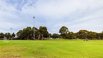
The following map shows the ground investigation locations within, or adjacent to, the project corridor:
Map: Ground investigation sites
Map disclaimer
Site contamination assessments undertaken have determined whether chemicals of concern have been used in the project corridor, including adjacent properties, by looking for what are termed potentially contaminating activities (PCAs). Examples of PCA include historical or currently operational service stations, car manufacturers or dry cleaners. If it is determined that a PCA has occurred, then there is a potential that chemicals have been released into and remain in the environment.
A site contamination assessment is generally a two-staged approach and consists of:
- a desktop assessment that looks to identify if PCAs have occurred on or adjacent to the proposed roadway and includes:
- a review of publicly available records
- interviews with staff who have worked at, or adjacent to, the site
- a review of historical aerial photographs
- a site walkover.
- if PCAs have not occurred within an area then it is unlikely that site contamination exists and further assessment is generally not required. If PCAs are identified then a ground investigation is usually undertaken.
A ground investigation is a physical assessment that generally involves the collection of soil, groundwater, surface water and/or vapour samples for laboratory testing. This will determine whether any chemicals of concern are present and whether they are at levels that may pose a risk to health or the environment. A given site might be revisited several times to further assess whether chemicals are present.
Site contamination is usually historical and not generally associated with the construction and operation of the project itself. If a potential risk is identified then these areas will be managed to prevent risk to health and the environment as part of the construction process.
Assessment area
Potentially contaminating activity sites
Numerous desktop assessments have been completed for properties within or adjacent to South Road between 2008-2020. The most recent desktop assessment in 2020 identified more than 350 properties adjacent to South Road where PCAs may have occurred.
The following map identifies the PCAs within, or adjacent to, the project corridor:
Map: Potentially contaminating activities
Map disclaimer
The PCAs shown on the map are colour coded as yellow (high priority), blue (medium priority) and green (low priority). The colours are not an indication of actual risk but have been ranked based on the type of PCA identified and distance from the project design. For example, a service station currently within the project area may be yellow (high priority) whereas a service station 500m from the project may be green (low priority).
Many of the PCA sites have already been investigated. Further PCA sites will be investigated as they are acquired in preparation for construction.
Groundwater prohibition areas
Several of the PCAs adjacent to the project corridor are associated with existing site contamination that has previously been investigated and reported to the EPA. The EPA can declare a Groundwater Prohibition Area (GPA) where groundwater is found to be a potential risk to health. This means that people living within a GPA area are not allowed to access the groundwater from private bores for drinking or to water their gardens.
It is important to note that this only applies to water from private bores that are installed within a given property and does not apply to tap water. An information sheet prepared by the EPA describes why GPAs are declared and what this means, which can be found here.
Individual GPAs are named after the suburbs that they fall within. The project will run through, or is adjacent to, the following four GPAs:
- GPA 1 - Thebarton and Mile End
- GPA 2 - Keswick, Forestville, Ashford, Everard Park, Wayville and Mile End South
- GPA 3 - Edwardstown, South Plympton, Plympton Park, Ascot Park, Park Holme and Melrose Park
- GPA 4 - Tonsley, and parts of Clovelly Park, Mitchell Park and Marion.
The following map shows the groundwater prohibition areas along the project corridor:
Map: Groundwater prohibition areas
Map disclaimer
Further details on each of the four GPAs can also be found on the EPA website.
As the tunnels and portions of the open motorway will extend below ground level, the excavations will extend into one or more of the GPAs. Construction of portals and the tunnels will require the extraction of groundwater to allow excavation. This water will be treated and re-used or disposed of in an environmentally responsible manner following consultation with the EPA.
Acid sulfate soils
Acid sulfate soils are naturally occurring and can be found within South Australia, particularly in coastal areas. When they are exposed to air, they can result in the release of acid that can kill aquatic life or damage concrete structures such as tunnels. The excavation and release of acid sulfate soils is classed as a PCA. A review of acid sulfate soils was undertaken as part of the desktop assessment works completed for the project. According to Australian National Soil Information System there is an extremely low probability of acid sulfate soil occurrence, i.e. it is deemed highly unlikley that acid sulfate soils are present within or adjacent to the T2D Project.
Acid sulfate soils have also not been detected in the ground investigations completed to date. Therefore, acid sulfate soils are unlikely to be a risk to health and the environment during the construction or operation of the project.
The following map shows acid sulfate soil probability adjacent to project corridor:
Map: Acid sulfate soils
Map disclaimer
Existing environment
Potential site contamination risks to health and the environment during the construction and operation of the project are highly dependent on the infrastructure design and the type of contamination found in the given area. In order to summarise the site contamination identified to date, the project corridor has been split up into the following five areas:
- Area 1 – Northern surface works
- Area 2 – Northern Tunnels
- Area 3 – Open motorway
- Area 4 – Southern Tunnels
- Area 5 – Southern surface works.
The following map shows the five assessment areas along the project corridor:
Area 1 - Northern surface works
This portion of the project will comprise of lowered and at grade roads connecting Grange Road, Hindmarsh to the Northern Tunnels. A deeper excavation will be required to allow the Northern Tunnels to be constructed. A total of 17 PCA sites were identified in Area 1 during the 2020 desktop assessment.
Soil
A total of 152 soil samples from 33 soil bores drilled in Area 1 were submitted for laboratory chemical analysis.
Potential risks to health and/or the environment were identified:
- beneath the surface at one location within the footprint of the proposed lowered motorway; this material will be removed during project construction
- west of the project at depth within a former brickworks landfill, as the landfill is outside of the project corridor no excavation is planned to occur
- within a former landfill at Langman Reserve; a new surface road will need to be constructed in this area so the surface material will need to be excavated to allow the construction of a new roadway.
The chemicals found in these locations would only be a risk to health if a person had direct contact with these soils for many years. As the chemicals are at depth there is currently no risk to health. Any excavated material will be disposed of at a suitable landfill facility.
Groundwater
During the construction of the lowered motorway the excavations will reach groundwater, including within the Thebarton and Mile End GPA. As expected, the testing of the groundwater in this area has identified chemicals that may be a risk to health. The levels of chemicals detected would be generally unsafe if someone was to drink the water continually over a long time.
During construction all groundwater encountered will be removed, treated and re-used or disposed of in an environmentally safe manner.
Area 2 - Northern Tunnels
This portion of the project will comprise of two tunnels at a maximum depth of approximately 30m below ground.
Soil
A total of 157 soil samples from 38 soil bores were submitted for laboratory chemical analysis from Area 2. The chemicals detected were identified as not presenting a risk to health or the environment. The construction of two tunnels, at depth, within Area 2 means it is unlikely that further areas of site contamination will be encountered in any of the 41 PCA sites identified in Area 2.
Groundwater
A variety of chemicals were found in the groundwater beneath Area 2. The levels of chemicals detected would be generally unsafe if someone was to drink the water continually over a long time.
During construction all groundwater encountered will be removed, treated and re-used (if possible) or disposed of in an environmentally safe manner.
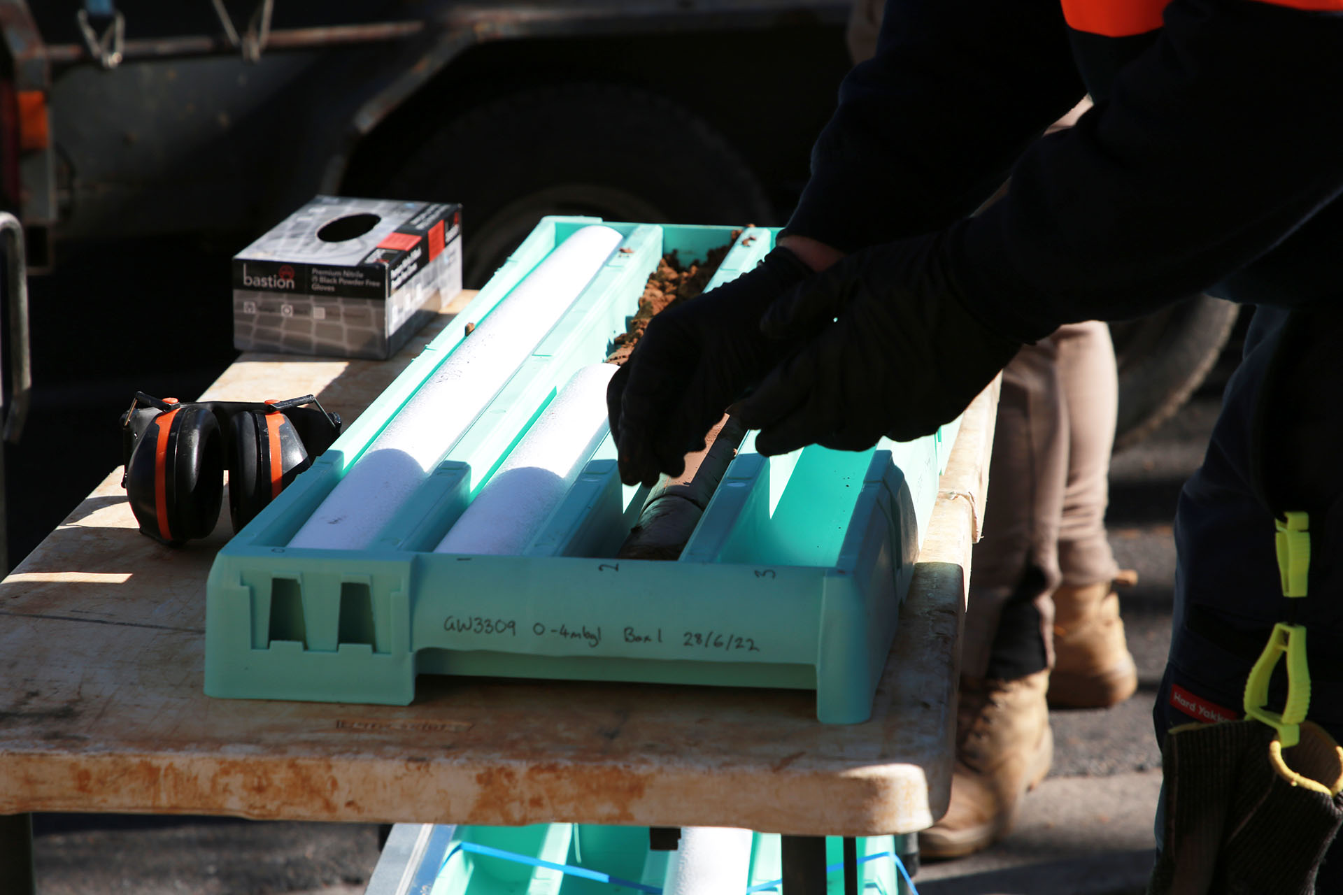
Photo: Soil samples from the Project Corridor being organised for analysis.
Area 3 - Open motorway
This portion of the project will comprise lowered and at-grade roads connecting the Northern and Southern Tunnels. Deeper excavations will be required to allow the construction of the Northern and Southern Tunnels. A total of 85 PCA sites of varying assigned risk have been identified in Area 3.
Soil
A total of 417 soil samples from 88 soil bores were submitted for laboratory chemical analysis from Area 3.
Potential risks to health and/or the environment were identified:
- beneath a current roadway at a depth of approximately 5 m below ground level, due to the depth this material will not be disturbed during construction
- within the proposed lowered motorway; this location is beneath the surface and the material will be removed during construction
- several locations outside of the project corridor which will not be disturbed during construction.
The chemicals found in these locations would only be a risk to health if a person had direct contact with these soils for many years. As the chemicals are at depth there is currently no risk to health. Any excavated material will be disposed of responsibly at a suitable landfill facility.
Groundwater
During construction of the open motorway the excavations will reach groundwater, including within the Keswick, Forestville, Ashford, Everard Park, Wayville and Mile End South GPA. As expected, the testing of the groundwater in this area has identified chemicals that may be a risk to health if not appropriately managed. The levels of chemicals detected would be generally unsafe if someone was to drink the water continually over a long time which is unlikely.
During construction all groundwater encountered will be removed, treated and re-used (if possible) or disposed of in an environmentally safe manner.
Area 4 - Southern Tunnels
This portion of the project will consist of two tunnels up to 40m below ground.
Soil
A total of 594 soil samples from 81 soil bores were submitted for laboratory chemical analysis from Area 4. The construction of two tunnels, at depth, within Area 4 mean that it is unlikely that further areas of site contamination will be encountered in any of the 169 PCA sites identified.
One of the high priority sites identified during the desktop assessment was St Marys Fire Station. The ground investigations undertaken in the vicinity of the Fire Station have found low levels of per- and poly-fluoroalkyl substances (PFAS) in soils. PFAS was historically found in fire-fighting foams. Further details on PFAS usage as firefighting foams can be found on the Metropolitan Fire Service website.
PFAS contamination identified around St Marys Fire station is in the shallow soils. The tunnels within Area 4 are proposed to be more than 20m beneath the Fire Station and to the west of where PFAS was found. The construction of the tunnels is unlikely to go through PFAS containing soils. PFAS found in these locations would only be a potential risk to health if a person had direct contact with these soils.
Further investigation of St Marys Fire station is on-going outside of the project.
Groundwater
During the construction of the Southern Tunnels the excavations will reach groundwater, including within the Edwardstown, South Plympton, Plympton Park, Ascot Park, Park Holme and Melrose Park GPA. As expected, the testing of the groundwater in this area has identified chemicals that may be a risk to health if not appropriately managed. The levels of chemicals detected would be generally unsafe if someone was to drink the water continually over a long time.
During construction all groundwater encountered will be removed, treated and re-used (if possible) or disposed of in an environmentally safe manner.
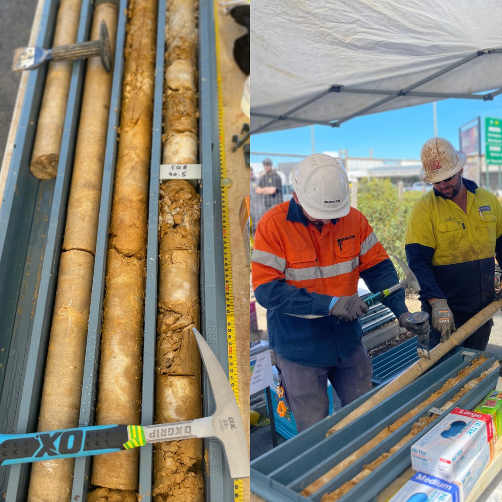
Photo: Soil bores taken near Daws Road, Edwardstown.
Area 5 - Southern surface works
This portion of the project will comprise lowered and at-grade roads connecting the Southern Tunnels to the existing Southern Expressway. Deeper excavations will be required to allow the construction of the Southern Tunnels. A total of 41 PCA sites of varying assigned risk have been identified in Area 5.
Soil
A total of 216 soil samples from 39 soil bores were submitted for laboratory chemical analysis from Area 5. None of the chemical concentrations were at a level that would pose a risk to health.
Groundwater
A variety of chemicals were found in the groundwater beneath Area 5. The levels of chemicals detected would only be generally unsafe if someone was to drink the water continually over a long time.
During construction all groundwater encountered will be removed, treated and re-used or disposed of in an environmentally safe manner.
Impacts and mitigation measures
During construction and operation of the T2D Project, there is potential for site contamination to affect health and/or the environment if not managed appropriately. An evaluation of several potential site contamination impacts was undertaken for the construction and operational phases of the project.
For there to be an actual risk to health or the environment the following three components are required:
- Source: Chemicals of concern in soil, groundwater, surface water and / or the air.
- Pathway: A process where these chemicals can move within the environment.
- Receptor: Something that can be affected by the chemical for example a construction worker or an adjacent waterway.
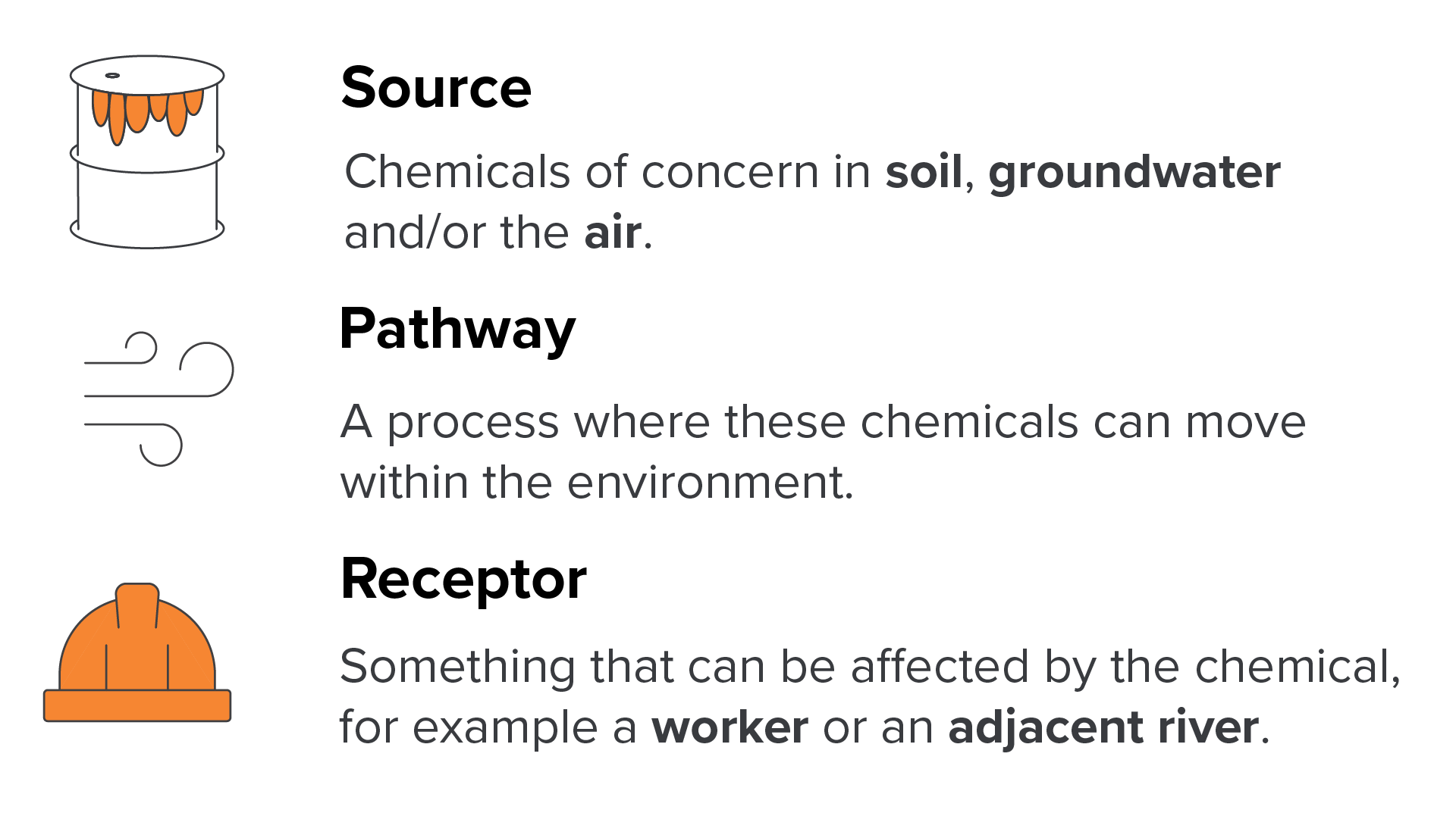
If one of more of these three components are absent then there can be no risk.
Several locations within the project corridor have soil and groundwater chemical levels which may be a “potential risk to health or the environment.” It should be noted that health effects for these chemicals would only occur if a person was constantly exposed on an almost daily basis over multiple years (often decades). A one-off exposure or limited exposure over a few days or months is unlikely to result in any health effects.
Various processes will be put in place during the construction and operational phases of the project to minimise potential risks to health or the environment.
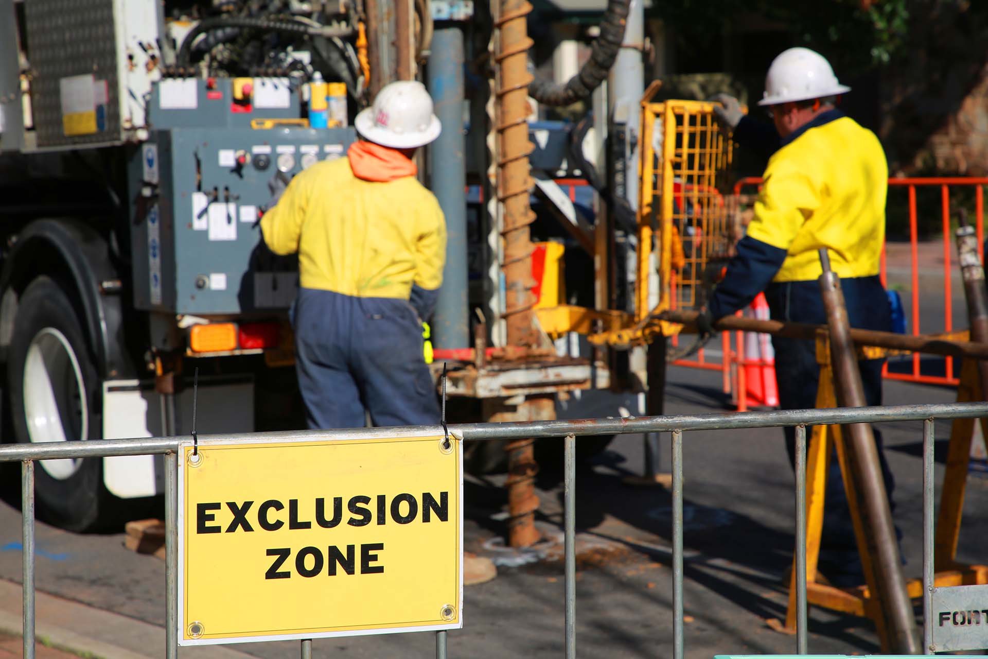
Photo: Workers undertaking ground investigations.
The potential impacts to health and the environment have been assessed by applying the project’s assessment methodology to the health and the environment areas of interest. The objective of this assessment methodology is to document and assess the social and environmental (including heritage) risks from the project and identify management and mitigation measures to reduce these risks.
Construction impacts
Potential construction impacts are heavily dependent on the type of infrastructure present such as open motorway (lowered motorway) and connector roads compared to tunnels. The assessments identified the following site contamination impacts that may occur during construction.
Soils
The construction of the open motorway sections and to a lesser degree connecting roads are likely to encounter known and previously unknown areas of site contamination present. For example, the northern surface works (Area 1) will pass through Langman Reserve (an identified PCA site) which is to the north of River Torrens / Karrawirra Parri. The reserve is located above a former pit that was historically filled with material from unknown sources. Some of the surface material will need to be excavated and disposed of outside of the project so new material can be used to construct the proposed road foundations.
The deeper soil in the tunnels occasionally contains chemicals but generally at much lower concentrations.
There are normal procedures and mitigation measures that will be implemented to prevent the below listed impacts from occurring. The excavation and transportation of this soil out from the project site could potentially lead to chemical exposure to:
- construction workers who come into contact (such as skin contact with soils or inhalation of dust) with excavated soils (open motorway and tunnels) during the excavation and loading of the material onto trucks
- the general public who come into contact with soils that are being transported in trucks for disposal outside of the project corridor. This is most likely through the inhalation of dust that may be generated during excavation works or blown from the trucks. Soils may also be carried out of the project corridor on vehicle tyres
- the deeper groundwater beneath the motorway as soils could be washed into deeper excavations
- adjacent rivers/creeks should soils fall off vehicles and be washed into the adjacent river or should rainfall wash soils from the project corridor to the rivers/creeks
- adjacent flora and fauna if soils fall off vehicles in adjacent reserves.
Groundwater
The excavation of the open motorway (lowered motorway), portals for the TBMs and the tunnels themselves will intersect groundwater that may have levels of chemicals that could be a risk to health and/or the environment, for example within the groundwater prohibition areas.
This could lead to chemical exposure to:
- construction workers who come into contact (such as skin contact with groundwater or inhalation of water droplets) with groundwater pumped out of the excavations to allow the excavation of soil
- the deeper groundwater beneath the motorway as shallow groundwater from the groundwater prohibition areas flows into deeper excavations.
The public will not be allowed access to the construction areas so they will not come into contact with groundwater during the project construction.
There are normal procedures and mitigation measures that will be implemented to prevent the above listed impacts from occurring. The measures are outlined in the table below.
Vapour
The excavation of soils and removal of groundwater from excavations may lead to the release of chemicals into the air (known as vapours). This may lead to chemical exposure to:
- construction workers who inhale vapours from soil or groundwater during the construction of the open motorway and connector roads only
- the general public who may walk past the project corridor during the removal of soils and groundwater. Vapours are unlikely and if present will mostly remain in the excavations so the potential for the public to inhale chemicals would be highly unlikely and of short duration.
There are normal procedures and mitigation measures that will be implemented to prevent the above listed impacts from occurring. These measures are outlined in the table below. See how impacts will be minimised or avoided for further information.
Site contamination impact mitigation requirements for construction
Potential construction impacts | Key mitigation measures |
|---|---|
Construction worker exposure to soil, groundwater and/or vapours | The project will:
|
General public, flora and fauna exposure to soil, groundwater and/or soil vapour | The project will:
The general public and adjacent flora and fauna will not be exposed to groundwater. |
Soils washed into adjacent surface water bodies such as the River Torrens | The project will have a Soil Erosion and Drainage Management Plan (SEDMP) which will identify measures to minimise potential for soil or surface water entering adjacent water bodies. This may include:
|
The movement of shallow groundwater contamination into deeper groundwater | The project will:
|
Operational impacts
Operational impacts are anticipated to be limited for this project as any areas of site contamination identified during construction will be removed.
Site contamination impact mitigation requirements for operations
Potential operational impacts | Key mitigation measures |
|---|---|
The movement of shallow groundwater contamination into deeper groundwater | Groundwater will be removed gradually as excavation of open motorway and cut and cover portals. The installation of diaphragm walls will limit the potential mobilisation of shallow groundwater activation into deeper groundwater. |
How impacts will be minimised or avoided
During design the project has confirmed that application of the Department’s Master Specification (MS), with its links to relevant parts of the Environment and Heritage Technical Manual (EHTM) will be applied to mitigate the construction and operational impacts to site contamination.
Of relevance to site contamination are:
- MS PC-ENV1 – Environmental Management;
- MS PC-ENV2 – Environmental Protection Requirements;
- MS PC-SC1 – Site Contamination
- MS RD-EW-C1 – Earthworks
- MS M7 – Environmental Management
- EHTM Attachment 6A – Protecting Waterways Guideline
- EHTM Attachment 6B – Water Affecting Activities Best Practice Operating Procedure
- EHTM Attachment 9A – Guideline for the Beneficial Reuse of Solid Waste
- EHTM Attachment 9B – Guideline for the Assessment and Management of Acid Sulfate Soils
- EHTM Attachment 10A – Guideline for the Preparation of a Contractor's Environmental Management Plan
During Project construction the following Guidance will be adopted:
- SA EPA Guidelines for the assessment and remediation of site contamination (SA EPA 2019)
- EPA 889/10 Current criteria for the classification of waste – including Industrial and Commercial Waste (Listed) and Waste Soil (SA EPA 2010)
- Standard for the production and use of Waste Derived Fill (SA EPA 2013)
- SA EPA Guidelines for the site contamination audit system (2019)
- SA EPA Guideline for stockpile management (October 2020)
- SA EPA Construction environmental management plan (CEMP) Guidelines
- SA EPA Environmental management of dewatering during construction activities
- SA EPA Code of practice for the building and construction industry – stormwater pollution prevention (March 1999)
- SafeWork Australia Excavation work code of practice
- SafeWork SA Respiratory protective equipment (RPE) Guidelines
- SafeWork SA Code of Practice – Confined Spaces (2020).
Project design opportunities
Design mitigation opportunities to minimise site contamination impacts have been identified for further consideration and incorporation during Detailed Design, in accordance with the Department’s MS and EHTM requirements. It is noted that the design changes proposed below would result in a fundamental redesign of the project corridor but have been included for completeness.
Design mitigation opportunities location summary
Impact | Design opportunity |
|---|---|
Construction worker exposure to contaminants of potential concern in soils, groundwater and/or vapours during the construction of the lowered motorway | Adjustment of the lowered motorway alignments away from areas of known contamination such as Langman Reserve, other high risk PCA sites along South Road or the four GPAs. It is unlikely that any re-routing of the Project Design within the corridor would avoid all adjacent PCA sites. |
Potential mobilisation of contaminated groundwater into adjacent and/or deeper (and potentially less contaminated) aquifers | Reduce construction depth to limit the potential interaction with deep aquifers along the project corridor. It is noted that this would result in the project going potentially through the shallow aquifers of all four GPAs and that this would potentially increase the exposure to contaminated groundwater in the GPAs. |
Approvals
Approvals, permits and authorisations
Legislation | Approval |
|---|---|
Required | |
Prescribed activities, including wastewater treatment documented in Schedule 1 of the EP Act including earthworks drainage licencing requirements and resource recovery, waste disposal and related activities which help minimise water quality impacts that have the potential to affect terrestrial and aquatic flora and fauna. The EP Act establishes the general environmental duty to not undertake an activity that pollutes or might pollute the environment, unless all reasonable and practicable measures to prevent or minimise any resulting environmental harm have been taken. The project must comply with the general environmental duty to prevent or minimise environmental harm associated with the construction and operation of the T2D Project. Environmental authorisations may be required for any activity classified as a prescribed activity of environmental significance under Schedule 1 of the EP Act. Earthworks drainage for dewatering, whereby wastewater containing suspended solids exceeding 25mg/L. Earthworks drainage is a 'prescribed activity of environmental significance', Schedule 3, Class 2. | |
The Environment Protection Regulations 2009 provide the regulatory framework in line with the EP Act. Part 5 – Site Contamination:
The project design is assessed against this prescribed list of PCAs which will guide the risk assessment process and prioritise intrusive investigations. | |
The Environment Protection (Water Quality) Policy defines key environmental values and water quality targets for all surface water and groundwater resources. Industry and community obligations are defined for preventing (or minimising) water polluting activities. Provides guidance on reducing the affects the project may have on groundwater quality. | |
The environment protection (waste to resources) policy provides definitions of when material may be declared not to be a “waste” and requires for that material to be ready and intended for imminent use. Consideration should also be given to the material properties of the tunnel boring spoil in terms of physical properties in conjunction with the chemical analysis results. Certain material declared not to be waste: For the purposes of section 4(2)(b) of the Act, waste or other matter is declared not to be waste if—
| |
Standard for the production and use of Waste Derived Fill (2013) | This standard describes the processes that are required by the EPA to support the waste management hierarchy through the beneficial reuse of a range of wastes. The guideline specifically notes that “Waste Derived Fill must be similar to virgin solid mineralogical materials naturally present in the soil profile (such as inert soil, rock, sand and silt)” The guideline also provides for a risk based approach to mitigating harm through consideration of both the source of the waste (proximity to PCAs) and the concentrations of chemicals present in the soils. A site contamination auditor, accredited under the Division 4 of Part 10A of the EP Act, must be engaged by a proponent for the importation and use of soils with chemical concentrations exceeding the waste fill criteria. |
This guideline outlines the legislative framework and the roles and responsibilities of various stakeholders within the site contamination audit system. | |
EHTM Attachment 6A – Protecting waterways Guideline | Demonstrate compliance. No specific Departmental approval required. |
EHTM Attachment 6B – Water Affecting Activities Best Practice Operating Procedure | Demonstrate compliance. No specific Departmental approval required. Landscape SA Board approval, a result of applying EHTM Attachment 6B is required. |
EHTM Attachment 9A – Guideline for the Beneficial Reuse of Solid Waste | Demonstrate compliance. No specific Departmental approval required. |
EHTM Attachment 9B – Guideline for the Assessment and Management of Acid Sulfate Soils | Demonstrate compliance. No specific Departmental approval required. |
EHTM Attachment 10A – Guideline for the Preparation of a Contractor's Environmental Management Plan | Demonstrate compliance. The following additional management plans are required to manage the potential risks associated with site contamination:
|
Next steps
The Project Assessment Report (PAR) community consultation period concluded in April 2024. We thank you for your feedback.
The valuable information and local insights received during the consultation phase of the PAR are being considered by the project team and will inform the ongoing refinement of the T2D Project.