Ecology
- Summary
Download a summary of the Ecology impact assessment in PDF format
Approach
Multiple investigations and assessments of identified and potential impacts to the surrounding ecological environment caused by the construction and operation of the T2D Project have been undertaken across several years as the design evolved.
Investigations and assessments undertaken include:
- ecological assessments of the project corridor, to confirm the presence/absence of Matters of National Environmental Significance (MNES) in addition to state threatened flora and fauna
- ecological assessments of the project corridor to confirm the location of kerbside and median amenity flora including landscape plantings - this also identified locations of the Department’s Roadside Significant Sites
- a native vegetation assessment of the section of the River Torrens / Karrawirra Parri where the project corridor passes over the river corridor and the Native Vegetation Act applies
- an arborist assessment of the Anzac Highway street trees in proximity to the South Road intersection between Ashford/Everard Park and Kurralta Park/Glandore.
These assessments, which involved a combination of field surveys and desktop investigations, explored the presence or absence of the following within or immediately adjacent to the project corridor:
- Matters of National Environmental Significance (MNES)
- state threatened flora and fauna
- remnant native flora
- regulated and significant trees
- high-value flora
- the Department’s Roadside Significant Sites
- kerbside and median amenity flora
- flora at acquired properties
- aquatic fauna and flora
- public spaces, gardens and reserves.
Assessment area
The ecological impact assessment area focuses on the project corridor plus a buffer of approximately 100m and considers public spaces, gardens and reserves which are in immediate proximity.
The following map shows the location of significant, regulated and amenity trees on public land within the impact assessment area (surveyed 2021/2022).
While the project assessment has considered potential impacts to all flora within the project area, those trees identified as outside of the extent of surface works have not been shown on this map as they are not within the vicinity of the construction at surface and not expected to be impacted.
Map: Ecology assessment area.
Map disclaimer
Existing environment
The project is located within a highly-urbanised area of metropolitan Adelaide. Because of this, it is already highly modified and comprises very limited native vegetation but does feature some scattered Regulated and Significant trees and kerbside amenity flora.
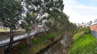
North of Anzac Highway there are medium to large trees (including those of Regulated and Significant size) located in properties immediately adjacent to South Road. These trees are scattered between mature trees in the South Road corridor and amenity plantings of London Plane trees (Plantanus acerifolia) in several sections of the road corridor up to the River Torrens / Karrawirra Parri.
Photo: London Plane (Plantanus acerifolia) trees on South Road.
South of Anzac Highway, there is generally an absence of mature trees located along the existing South Road corridor. Isolated large amenity trees (including those of Regulated and Significant size) are located at some properties immediately adjacent to South Road.
Further information for each ecological attribute within and immediately adjacent to the South Road corridor is summarised below.
Matters of National Environmental Significance
Matters of National Environmental Significance include species, habitats and ecological associations and are protected by the Commonwealth Environment Protection and Biodiversity Conservation Act 1999 (Cth).
The Protected Matters Search Tool (PMST) identified one Threatened Ecological Community (TEC), 30 threatened flora and fauna species and 15 listed migratory fauna species potentially present in the assessment area.
The TEC that the PMST identified included Grey Box (Eucalyptus microcarpa) Grassy Woodlands and Derived Native Grasslands of South-eastern Australia, and that these could potentially occur within the South Road corridor. Since the surveyed area is highly urbanised it was deemed highly unlikely that this TEC existed, which was later confirmed during site survey.
Threatened flora and fauna species (National and State significance)
Nationally threatened flora
The PMST and Biodiversity Database of South Australia (BDBSA) desktop search identified two nationally listed flora species as potentially being present in the South Road corridor; the Mount Compass Oak-Bush (Allocasuarina robusta) and Plum Leek-orchid (Prasophyllum pruinosum). As the assessment area is highly urbanised, it was deemed unlikely that these species would appear on site and their absence was also confirmed during site surveys.
State threatened flora
The BDBSA desktop search identified 19 species of threatened flora listed at the state level recorded within 5km of South Road. The majority of these occur in conservation reserves and as the location is highly urbanised it is considered unlikely that any of these species will be present outside of these reserves.
Two species that were assessed as possibly occurring are Pink Gum (Eucalyptus fasciculosa) and Flinders Ranges Wattle (Acacia iteaphylla) however their absence was confirmed during the site survey.
Nationally threatened fauna
The PMST search identified two mammal species and six birds listed at the national level (not including species listed as marine or migratory species) as potentially being in the South Road corridor. The bird species the White-throated Needletail (Hirundapus caudacutus) was assessed as possibly having a presence in the area but is predominantly aerial, and with an absence of preferred nesting habitat is therefore considered unlikely to be impacted by the proposed works.
The Grey-headed Flying-fox (Pteropus poliocephalus) and Southern Brown Bandicoot (Isoodon obesulus obesulus) possibly use habitat along the South road corridor. Multiple records of the Grey-headed Flying-fox from the surrounding area (5km radius) suggest that this nocturnal species is likely present.
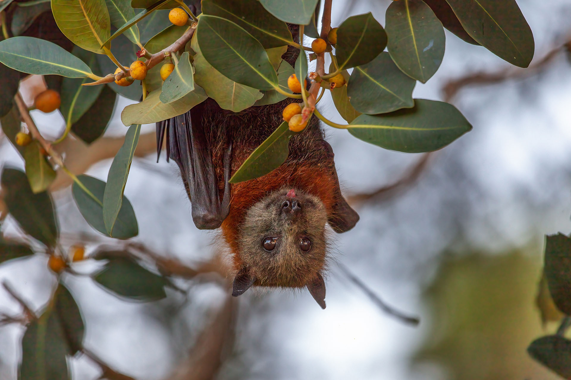
Photo: Grey-headed flying fox (Pteropus poliocephalus).
Only scattered records of the Southern Brown Bandicoot occur within the assessment area, but not within South Road itself. Most records suggest it may be present in nearby conservation reserves such as the Sturt Gorge Recreation Park. Due to this, it is not envisaged there will be any impacts to the bandicoot.
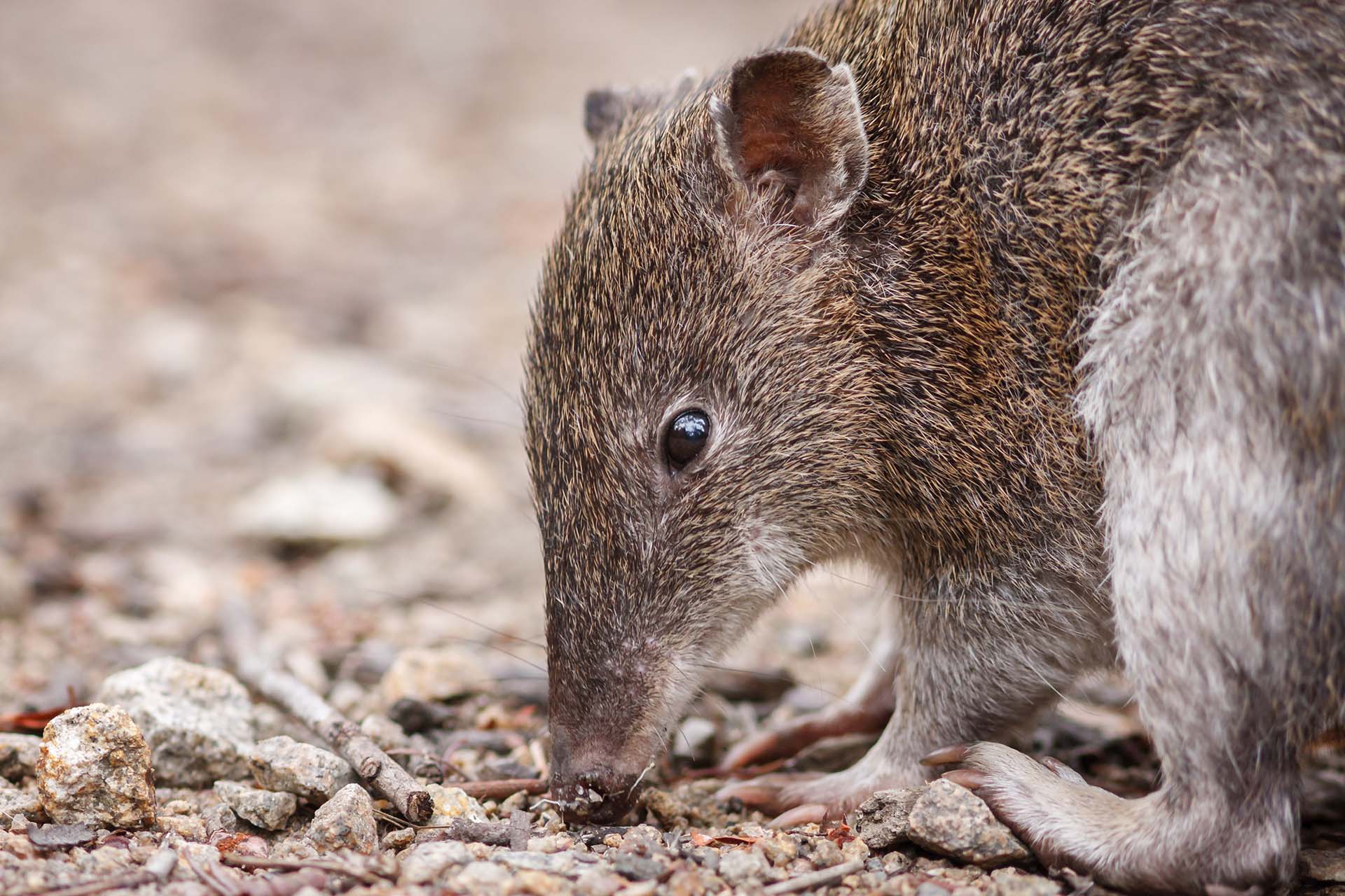
Photo: Southern Brown Bandicoot (Isoodon obesulus).
While the Grey-headed Flying-fox was not recorded during field surveys, previous records within 5km of South Road suggests the species is likely to forage among suitable trees within the area.
This species has wide habitat preferences, which have also seen recorded numbers of the species increase in and around metropolitan Adelaide across the past 10 years (a well-known colony exists in the Adelaide Park Lands). The species is not known to camp or breed along the South Road corridor.
State-threatened fauna
The 5km radius BDBSA desktop search identified one mammal species, 15 bird species, three reptiles and one amphibian species that may be present within the South Road corridor. One listed bird species the Spotless Crake (Zapornia tabuensis), was assessed as possibly being present.
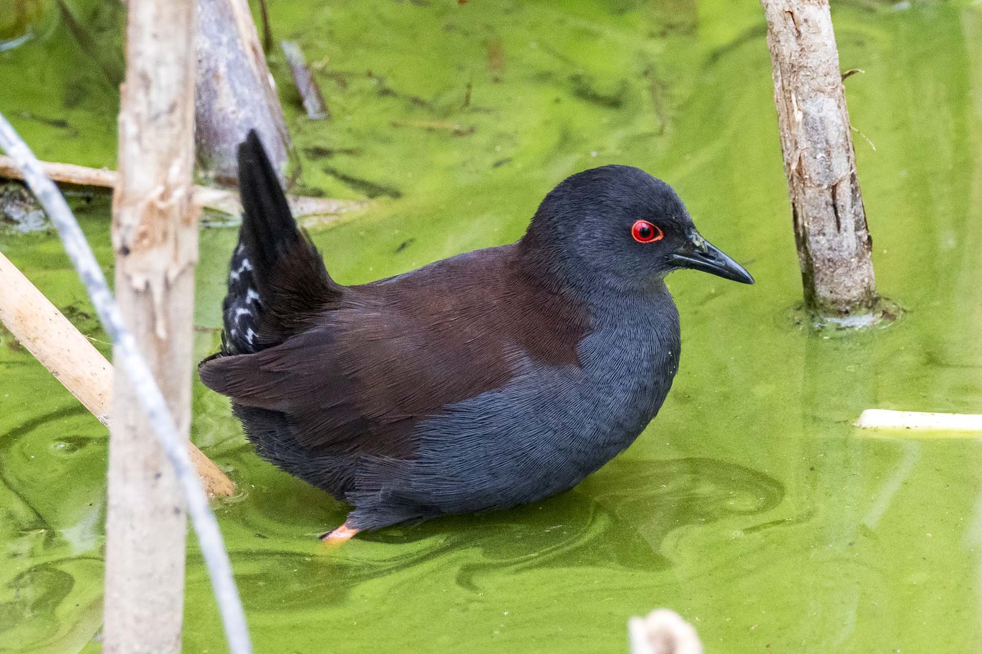
Photo: Spotless crake (Zapornia tabuensis).
All other listed birds and reptiles were deemed to be unlikely occupants or visitors to the South Road due to the absence of suitable habitat. One mammal species, the State-threatened Common Brushtail Possum (Trichosurus vulpecula) was identified as possibly using the habitat within the South Road corridor.

Photo: Common Brushtail Possum (Trichosurus vulpecula).
Roadside Significant Sites (RSS)
Roadside Significant Sites (RSS), as defined by the Department are sites of high environmental or cultural significance along rail corridors and public road reserves. Of the trees surveyed for the ecological assessment, trees at two locations contribute to RSS:
- RSS 500, located along Anzac Highway comprises an avenue of Claret Ash (Fraxinus angustifolia ssp. Oxycarpa) trees, which were planted along Anzac Highway in the 1930’s. This avenue of trees has both environmental and cultural significance.
- RSS 582, located east side of South Road near Walsh Avenue, St Marys, consists of two River Red Gum (Eucalyptus camaldulensis) trees.
Regarding the Claret Ash trees (RSS 500), the project is looking to minimise impacts to ensure as many trees are retained as possible. However, there is potential that some trees may still be impacted, primarily on the northern side of Anzac Highway between Selby Street and South Road.
Photo: RSS 500 - Avenue of Claret Ash trees along Anzac Highway.
Remnant native flora
With the exception of the River Torrens / Karrawirra Parri, South Road is not subject to the Native Vegetation Act 1991. Several of the scattered trees within the River Torrens / Karrawirra Parri corridor have been confirmed as being remnant native flora. The overstorey species (including River Red Gum) along the river corridor consists of vegetation in good condition with the presence of hollows in some trees.
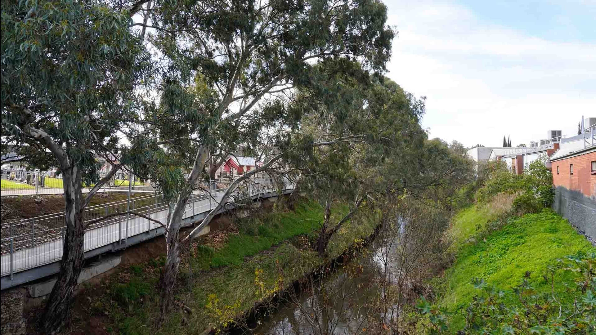
Photo: River Red Gum trees along the River Torrens / Karrawirra Parri.
Regulated and Significant trees
The ecological assessments identified that a total of 228 Regulated and Significant trees were situated within the surveyed area, consisting of 34 different species. This includes 158 Regulated trees and 70 Significant trees.
Many of these trees are located within River Torrens / Karrawirra Parri, Kings Reserve, along Anzac Highway and at Ragless Reserve which are adjacent to the project corridor or located in tunnel sections, which are less likely to be affected.
Ecological Assessment high-value flora
High-value vegetation, as defined in the ecological assessment, includes flora that provides habitat (such as hollows and foraging resources for native fauna species) and flora that includes native vegetation and/or is of high amenity value to the public. High-value flora identified within and immediately adjacent to South Road includes:
- 72 trees containing hollows identified at multiple locations including the River Torrens / Karrawirra Parri
- along South Road at St Marys Parish
- Ragless Reserve at St Marys
- trees and flora along the River Torrens / Karrawirra Parri at Hindmarsh (including both remnant native and planted amenity flora).

Photo: High-value flora at St Marys Parish.
Kerbside and median amenity flora
Kerbside and median amenity flora within the project corridor contributes to the ecological value along South Road. The kerbside amenity flora is summarised for each project section as:
- Northern Tunnels (Grange Road to south of Sir Donald Bradman Drive)
- between the River Torrens / Karrawirra Parri corridor and Sir Donald Bradman Drive intersection, large London Plane trees (Plantus acerifolia) are located at regular intervals on both the eastern and western kerbsides along South Road. There are no centre median plantings in this section.
- Open motorway (South of Sir Donald Bradman Drive to Anzac Highway)
- London Plane trees (Plantus acerifolia) have been planted on the eastern side of South Road between Sir Donald Bradman Drive and James Congdon Drive. There are five London Plane trees (Plantus acerifolia) on the eastern side adjacent to the RAA buildings at the South Road and Richmond Road intersection. South of Richmond Road there are scattered London Plane trees (Plantus acerifolia) on the eastern side and more consistently spaced plantings on the western side in proximity to Everard Avenue. The only centre median plantings are at the southernmost extent, those planted as part of the landscaping for the Gallipoli Underpass Project (2010).
- Southern Tunnels (Anzac Highway to Tonsley)
- between Anzac Highway and Forest Street at Glandore, there is densely planted amenity flora at the kerbside and in the centre median, planted as part of the landscaping for the Gallipoli Underpass Project (2010). Between the South Road Tram and Emerson Crossing overpasses, there are five trees located on the eastern side of South Road outside the Black Forest Shopping Centre. Several large eucalypts are located adjacent to the Emerson Overpass on the eastern side near the intersection of Cross Road. South of the Emerson Overpass, there is no kerbside (or centre median) amenity flora along the South Road corridor through to Tonsley.
In addition to the South Road corridor, kerbside amenity trees and flora are present within the road verges along each street joining South Road. The type, size, density and condition of the amenity trees and vegetation is variable depending on the suburb, the dominant land use types in those suburbs and each of the local government areas.
Photo: Kerbside amenity flora near South Road Tram Overpass.
Flora at acquired properties
The project requires numerous properties to be acquired to allow for construction. These properties include commercial, business, industrial and residential properties which, depending on land use, have varying amounts and quality of amenity flora that contribute to the ecology of the project corridor. Of all the land uses, amenity flora is primarily located in the gardens of residential properties.
The extent of flora in the acquired properties has not yet been quantified by the project, however the ecological value of this flora is being assessed at each site prior to demolition and land clearance occurring.
Aquatic fauna and flora
There are three watercourses that cross South Road which have potential for aquatic flora and fauna. These watercourses are:
- modified rock-lined earthen base section of the River Torrens / Karrawirra Parri at Hindmarsh
- modified concrete-lined Keswick Creek in proximity to the South Road/James Congdon Drive
- modified combination of earthen base and rock-lined section of Brownhill Creek / Willawilla at Ashford.
The existing environment for aquatic flora and fauna is yet to be assessed. Consultation with councils, stormwater boards (including Brownhill and Keswick Creek) and the Stormwater Management Authority (SMA) will be undertaken to confirm existing information regarding the presence or absence of aquatic flora and fauna within and beyond the South Road corridor. As part of this consultation, any projects, programs and priorities for habitat restoration for each of the three watercourses can also be confirmed.
Public spaces, gardens and reserves
Public spaces, gardens and reserves containing trees that provide ecological benefits and amenity have been identified within or in immediate proximity to South Road and are outlined in the table below.Section of alignment | Public space, garden or reserve (within and immediately adjacent to the South Road) |
|---|---|
Northern Tunnels |
|
Open motorway |
|
Southern Tunnels |
|
 Photo: Trees in and around the Thebarton Community Centre carpark.
Impacts and mitigation measures
Construction of the project has the potential to impact the ecology along and near the corridor. An evaluation of each ecological impact was undertaken for both the construction and operational phases of the project.
The potential impacts to ecology have been assessed by applying the project’s assessment methodology to the ecology assessment area.
The objective of the ecology assessment was to document and assess the social and environmental (including heritage) risks during construction and operation of the project and identify management and mitigation measures to reduce these risks.
For the Northern Tunnels and the open motorway sections of the project the key impacts are:
- land clearance and impacts to remnant native flora, high value flora, Regulated, Significant and large amenity trees, kerbside amenity flora, public spaces, gardens and reserves and flora at acquired properties
- construction activities within and around waterways potentially resulting in loss or degradation of aquatic and riparian flora (flora located on a river bank) that degrades aquatic habitat and loss of connectivity and/or impeded passage for aquatic fauna.
For the Southern Tunnels section of the project the key impact is:
- land clearance and impacts to Regulated, Significant and large amenity trees, kerbside amenity flora and flora at acquired properties.
Construction impacts
The construction activities that have the potential to impact ecology have been identified and the mitigation measures to minimise those impacts have been defined and summarised in the below table.
Potential construction impacts | Mitigation measures |
|---|---|
| Land clearance impacting remnant native flora, regulated, significant large amenity trees, high value flora, kerbside and centre median, amenity flora and flora at acquired properties. | The project will:
|
New infrastructure or modifications to existing infrastructure that impact aquatic flora and fauna. Activities within and around waterways resulting in loss connectivity and/or impeded passage for aquatic fauna. | The project will:
|
Construction activities that impact on retained high value flora. Soil compaction during construction that leads to loss or degradation to regulated, significant and large amenity trees. Adversely affecting the tree roots and ongoing health of regulated, significant and large amenity trees. | The project will:
|
| Habitat fragmentation resulting from impacts to wildlife corridors, or barriers to fauna movement. | The project will:
|
| Construction activities (for tunnel boring machines (TBM), lowered roads and tunnel portals) that require water earthworks drainage that release sedimentation and/or contaminants into waterways resulting in degradation of aquatic fauna and impact to aquatic species. | The project will:
|
Operational impacts
The operational activities that have the potential to impact ecology have been identified. Mitigation measures to minimise those impacts have been defined and summarised in the below table.
Potential operational impacts | Mitigation measures |
Shading from structures causing loss or degradation to remnant native flora, amenity flora and riparian vegetation that degrades aquatic habitat. Changes in the form and type of waterways resulting in loss of connectivity and impeded passage for terrestrial and aquatic species. | The project will:
|
Increased road traffic and non- permeable area resulting in increased pollutants (metals, hydrocarbons) in stormwater runoff to waterways that degrades aquatic ecosystems. Operational activities associated with the lowered road and tunnel portals that require ongoing drainage discharge (including groundwater) that releases sedimentation and/or contaminants into waterways resulting in degradation of aquatic ecosystem and impact to aquatic species. | The project will:
|
How impacts will minimised or avoided
During design the project has confirmed that application of the Department’s Master Specification (MS), with its links to relevant parts of the Environment and Heritage Technical Manual (EHTM) will be applied to mitigate the construction and operational impacts to ecology within and immediately adjacent to the project corridor.
Of relevance to ecology are:
- MS PC-ENV3 – Environmental Design
- MS PC-SI2 – Site Investigations
- MS PC-ST1 – Sustainability in Design (including the Green Infrastructure Assessment )
- MS PC-PL2 – Planning Investigations
- MS RD-DK-D1 – Road Drainage Design
- MS PC-ENV1 – Environmental Management
- MS PC-ENV2 – Environmental Protection Requirements
- MS PC-ST2 – Sustainability in Construction
- EHTM Attachment 1A – Environment and Heritage Impact Assessment Guideline
- EHTM Attachment 4A – Vegetation Survey Guideline
- EHTM Attachment 4B – Vegetation Impact Assessment Guideline
- EHTM Attachment 5A – Fauna Impact Assessment Guideline
- EHTM Attachment 6A – Protecting Waterways Guideline
- EHTM Attachment 6B – Water Affecting Activities Best Practice Operating Procedure
- EHTM Part 4 Vegetation Supporting document – Phytophthora (Dieback) Control Environmental Instruction.
These MS and EHTM sections require the project to develop and undertake assessments and prepare reports that document the required outcomes during construction. These include:
- Undertaking flora and fauna surveys and assessing the impacts in accordance with the EHTM (including the Vegetation Impact Assessment Guideline)
- Applying the Department’s vegetation impact mitigation hierarchy of avoid, minimise, rehabilitate and offset flora impacts during design, construction and operation
- Undertaking a Green Infrastructure Assessment, including seeking greater than 20% increase in canopy cover in accordance with the Department’s Green Infrastructure Commitment
- Ensuring opportunities for flora and fauna offsets, including flora species selection are documented and delivered as part of the Urban and Landscape Design outcomes
- Defining and maintaining a defined Contractor’s Activity Zone (CAZ) for construction
- Documenting and delivering a Contractor’s Environmental Management Plan (CEMP) that includes requirements for high value tree protection, including works in the Tree Protection Zone or Structural Root Zones.
Approvals
Ecology approvals, permits and authorisations | |
|---|---|
Required | |
Prescribed activities documented in Schedule 1 of the EP Act including earthworks drainage licencing requirements. “Resource recovery, waste disposal and related activities” minimise water quality impacts that have the potential to impact aquatic flora and fauna. The EP Act establishes the general environmental duty to not undertake an activity that pollutes or might pollute the environment, unless all reasonable and practicable measures to prevent or minimise any resulting environmental harm have been taken. The Project must comply with the general environmental duty to prevent or minimise environmental harm associated with the construction and operation of the Project. Environmental authorisations may be required for any activity classified as a prescribed activity of environmental significance under Schedule 1 of the EP Act. By way of example, earthworks drainage for dewatering, whereby wastewater containing suspended solids exceeding certain concentrations. Earthworks drainage is a 'prescribed activity of environmental significance', Schedule 3, Class 2. | |
The LSA Act promotes the sustainable and integrated management of the State’s natural resources. The LSA Act establishes a legal responsibility for landowners (and people undertaking activities on the landowner’s behalf) to take reasonable actions to manage pest species of fauna and flora declared under the Act, and to prevent land and water degradation. Under sections 104(3) and 104(4) of the LSA Act, a permit is required for water affecting activities unless the works are approved under another Act, such as the Planning Development and Infrastructure Act 2016, the Environment Protection Act 1993 or the Native Vegetation Act 1991. Water affecting activities are anticipated for works in the River Torrens / Karrawirra Parri, Keswick Creek and Brownhill Creek / Willawilla. Although unlikely, permits may also be required under the LSA Act, to permit the clearance, movement or disposal of plant matter or soil that may be contaminated by seeds or plant matter from a declared flora species. | |
EHTM Attachment 4A – Vegetation Survey Guideline | Demonstrate compliance. |
EHTM Attachment 4B – Vegetation Impact Assessment Guideline | Demonstrate compliance. The Department’s Environment and Heritage Technical Manual (EHTM) Attachment 4B – Vegetation Impact Assessment Guideline tables 5.1, 6.1, and 7.1 document the offset and approval requirements for amenity tree removals (including Regulated and Significant trees). |
EHTM Attachment 5A – Fauna Impact Assessment Guideline | Demonstrate compliance. |
EHTM Attachment 6A – Protecting waterways Guideline | Demonstrate compliance. |
EHTM Attachment 6B – Water Affecting Activities Best Practice Operating Procedure | Demonstrate compliance. |
EHTM Part 4 Vegetation Supporting document – Phytophthora (Dieback) Control Environmental Instruction | Demonstrate compliance. |
Required, under the following circumstance(s) | |
Only for remnant native vegetation impacted by the project within the River Torrens / Karrawirra Parri corridor. In accordance with the NV Act, clearance of native vegetation is subject to assessment, approval and offset. | |
Schedule 13 of the PDI Regulations provides that tree damaging activities undertaken by a State Agency are exempt from requiring development approval under certain circumstances, including: i. That is on any land:
| |
Should native animals require removal permits, in accordance with the National Parks and Wildlife Service Act 1972 may be required. | |
Not required | |
Environment Protection and Biodiversity Conservation Act 1999 (Cth) (EPBC Act) | In accordance with the EPBC Act actions that have, will have or are likely to have a significant impact on a Matter of National Environmental Significance (MNES) require Commonwealth approval. Significant impacts to Matter of National Environmental Significance (MNES) have been investigated and are not anticipated. |
Next steps
The Project Assessment Report (PAR) community consultation period concluded in April 2024. We thank you for your feedback.
The valuable information and local insights received during the consultation phase of the PAR are being considered by the project team and will inform the ongoing refinement of the T2D Project.