Our urban design journey
We are committed to enhancing both the new motorway and the communities along it.
Our urban design concepts have been shaped by community and key stakeholder feedback as the Project has developed.
In 2023, the Department for Infrastructure and Transport (DIT) released the T2D Urban Design Strategy, which set the groundwork for how urban design would be integrated into the Project.
The strategy was informed by:
government policies and strategies
local area analysis
best practice project benchmarking
community and stakeholder engagement.
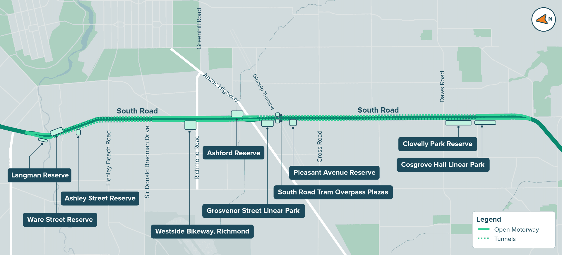
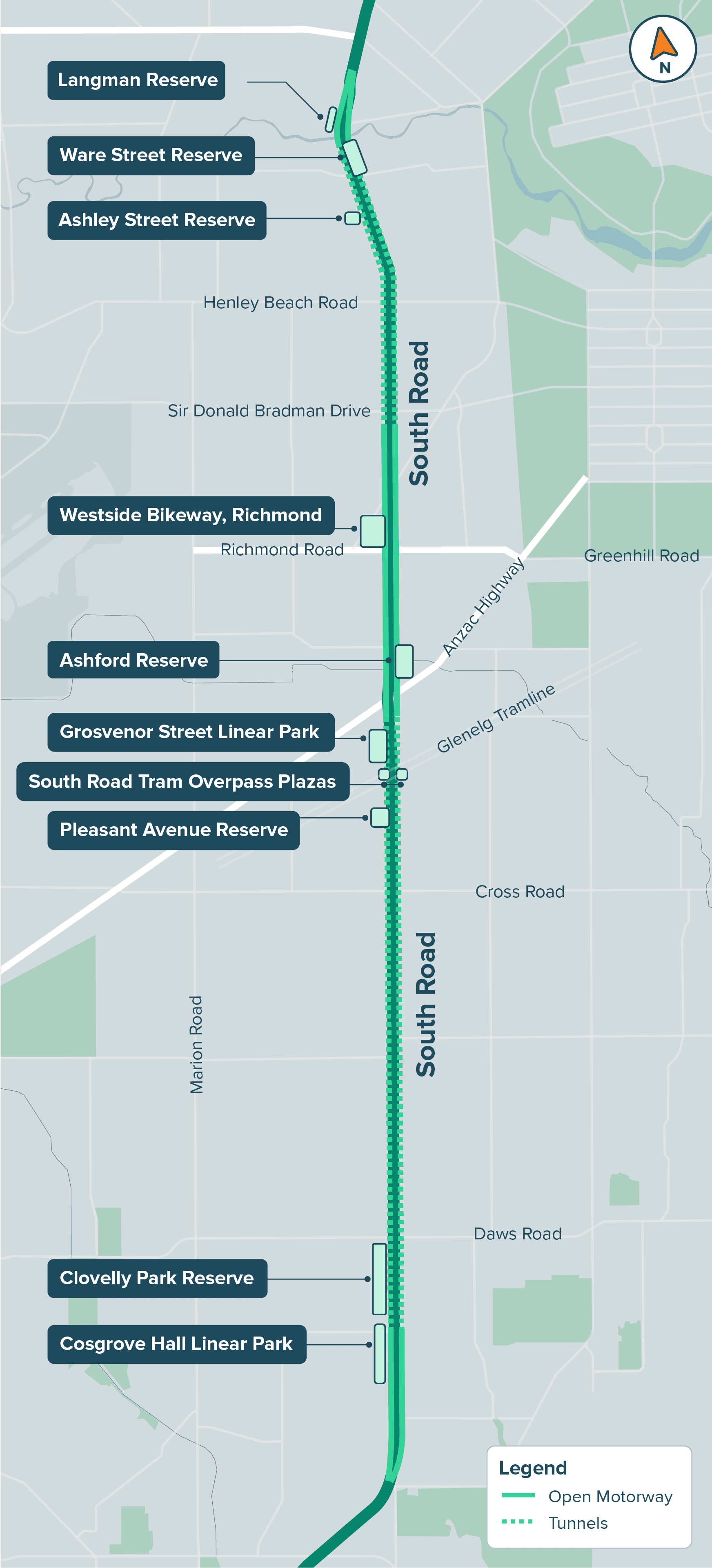
We've built on that and are now pleased to share 10 new open community spaces along the motorway for feedback. These will be welcoming places for people to connect, relax and enjoy. These spaces will also provide more opportunities for both play and sport – from playgrounds and grassed areas to courts and informal play spaces.
In 2026, we'll re-connect with local communities and stakeholders to provide further details on our designs.
Shaping Adelaide together
We’d like to hear what you think of the proposed open spaces and how you might use them.
The location of each space is outlined on the map below. You can also view the updated draft designs in more detail by visiting the interactive map.
Your feedback will help us finalise how these spaces look, feel and are enjoyed by the community. The designs will need final agreement from local Councils before they’re confirmed.
Please share your feedback by Sunday, 14 December 2025.
Key dates:
Consultation opens
18 November 2025
Consultation Closes
14 December 2025


The T2D Project will be constructed across three precincts - Northern, Central and Southern. Learn more about each precinct, including what we've heard so far and detailed descriptions of the proposed open spaces by clicking on the tabs below.
You can have your say on as many of the open spaces as you'd like, by sharing your feedback.
The Northen Precinct is located between Grange Road, West Hindmarsh and Ashley Street, Torrensville. It is the northern point of the T2D Project, where the 2.2km Northern Tunnels begin.
What we've heard so far
For this area, we’ve heard:
Keeping landmarks like the Brickworks kiln, Hindmarsh Cemetery and the Torrensville Bowling Club is important to local identity.
Improving access to Kings Reserve, Thebarton Oval and the River Torrens / Karrawirra Parri is a key focus.
New green space to complement facilities at Kings Reserve is needed.
Increasing amenity trees is important to provide shade and screening.
Creating stronger physical and cultural links with the newly relocated Warriappendi School is considered valuable for the community.
Key features
Entry and exit portal and maintenance and operations facility for the Northern Tunnels
Ware Street – 15,000 square metres of new community space
Langman Reserve – reimagined and upgraded
Trees – existing trees will be retained where possible and new plantings add to the green amenity
Ashley Street Reserve – upgraded facilities and connection to Thebarton Oval precinct
Enhanced walking and cycling paths to connect local areas of interest
Upgraded River Torrens Linear Park Trail, including a new path on the southern bank, crossing beneath South Road
Share your feedback
We welcome your feedback on the draft designs for the new Ware Street Reserve, revitalised Langman Reserve and Ashley Street Reserve. Learn about each space by clicking on its tile below.
Ware Street Reserve

Located next to the River Torrens / Karrawirra Parri, Ware Street Reserve will become an impressive 15,000 square metres of new open space.
Langman Reserve

Langman Reserve will be refreshed with upgraded facilities, creating a community space that feels both familiar and newly revitalised.
Ashley Street Reserve

A redeveloped Ashley Street Reserve will complement nearby facilities and have well- connected paths and entrances.
The Central Precinct is located between Sir Donald Bradman Drive, Hilton, and Glengarry Avenue, Glandore. It is where the lowered open motorway joins the Southern and Northern Tunnels.
The area is crucial for east-west connectivity and accessing the Adelaide CBD and airport.
What we've heard so far
For this area, we’ve heard:
Gardens and landscaping are important, with trees and green canopy particularly valued.
Providing facilities which cater for different activities and abilities – both formal and passive recreation – is important.
Continuous path networks and good access to nearby facilities are needed.
Shielding neighbouring areas from traffic noise is a key focus for local communities.
The existing memorials to ANZACs at the Gallipoli Underpass and Anzac Highway are valued by communities.
Key features
Spans the southern end of the Northern Tunnels to the northern end of the Southern Tunnels, with around 2.7km of lowered open motorway in between.
Four shared use bridges across the motorway, each complemented by green open space.
Enhanced Westside Bikeway connection and new green space at Deacon Avenue.
Richmond Oval – green space at the eastern entrance adds to street appeal.
Access to Richmond Primary School improved with a dedicated shared use bridge, and existing large Ficus tree retained.
Shared use bridge at Tennyson Centre Day Hospital which has direct ramp connections to Brown Hill Creek on eastern and western sides.
Activated open space beneath the new tram overpass to provide local communities with more active travel and leisure options.
Tunnel maintenance and operations facility, along with the Telstra Exchange.
Dedicated shared use bridge providing improved access to Black Forest Primary School, with open community space on the western side of the motorway.
Enhanced walking and cycling paths connecting local areas of interest and to public transport, including the City-Glenelg tram at Glandore.
Existing trees retained where possible and new plantings in multiple zones to green the area.
Share your feedback
We welcome your feedback on the draft designs for the new open spaces at:
Westside Bikeway, Richmond
Ashford Reserve
Grosvenor Street Linear Park
Pleasant Avenue Reserve
South Road Tram Overpass Plazas
Learn about each space by clicking on its tile below.
Westside Bikeway, Richmond

A dedicated shared use bridge across the motorway to complement the Westside Bikeway, with landscaped areas and shaded rest stops.
Ashford Reserve

Landscaped areas surrounding a new shared use bridge, providing access between Herbert Road and the Tennyson Centre Day Hospital.
Pleasant Avenue Reserve

A new green open space in Glandore, with a dog park, plaza areas and shared use bridge providing direct access to Black Forest Primary School.
Grosvenor Street Linear Park

A new linear park, offering a welcoming green space and active travel corridor between Grosvenor Street and the new motorway.
South Road Tram Overpass Plazas

The spaces beneath the newly rebuilt South Road Tram Overpass will be carefully re-imagined for the local community.
The Southern Precinct is located between Norrie Avenue, Clovelly Park, and Tonsley Boulevard, Tonsley. It is the southern point of the T2D Project, where the 4.5km Southern Tunnels begin.
What we've heard so far
For this area, we’ve heard:
Tree planting should focus on walking and cycling routes, recreation areas and locations that provide a buffer for residential areas from the motorway.
Safe connections to schools, public transport and recreation areas are important.
Desire for community spaces near existing halls and playgrounds.
Key features
Southern entry point of the T2D Project, where the 4.5km Southern Tunnels begin.
Cosgrove Hall Linear Park – a new green corridor improving amenity and visual appeal in front of the motorway.
Clovelly Park Reserve – a new community space on York Avenue.
Tunnel maintenance and operations facilities, along with a substation supporting the Southern Tunnels.
Tree retention where possible and new plantings to improve green canopy.
Enhanced walking and cycling paths connecting local schools, transport and recreation areas.
Dedicated shared use bridge providing safe access to St Bernadette’s School.
Share your feedback
We welcome your feedback on the draft designs for the new Cosgrove Hall Linear Park and Clovelly Park Reserve. Learn about each space by clicking on its tile below.
Cosgrove Hall Linear Park

A new biodiversity corridor at Clovelly Park with a variety of native plants that attract bees and birds, helping nature to thrive.
Clovelly Park Reserve

A new space opposite Clovelly Park Community Hall. It will feature a playground and open space for a variety of activities.
Resources
Download the fact sheets to learn more.
Other ways to get involved
Community consultation sessions
Come and chat with us at one of our local community consultation sessions in the coming weeks.
Community Information Centre
Visit our Community Information Centre to speak with our friendly team.
Where: 290 South Road, Hilton
Opening hours:
10am to 3pm, Monday - Friday
9am to 1pm, Saturday 6 December
We want to hear from kids too!
Design your dream neighbourhood activity sheet
What's on the sheet?
A fun challenge: Imagine you’re an urban designer!
Kids are invited to draw their dream neighbourhood - a place where people can walk and ride safely, enjoy nature, learn about local culture and have fun together.
Suggestions include adding paths, trees, gardens and playful places like playgrounds or murals that bring people together and honour local history.
Download the activity sheet
How to submit
Email: Send your entry to info@t2dalliance.com.au
In Person: Drop it off at the Community Information Centre, 290 South Road, Hilton SA 5033
Selected entries may be displayed at the T2D Community Information Centre, featured on the T2D website or newsletters, included in community exhibitions or pop-up events. Terms & conditions Entries must be original and created by children. By submitting, you agree that your entry may be publicly displayed or shared. Include your first name, age, school (optional). Entries may be used to promote community engagement and urban design education.